The National Weather Service has confirmed four tornado touchdowns in the early-morning hours Tuesday, including three in the KVOE listening area.
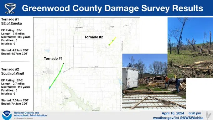
Greenwood County had two small tornadoes, an EF-1 tornado that touched down about two miles southeast of Eureka about 4:20 am and an EF-2 that developed about five miles south of Virgil a little more than three hours later. The EF-1 was on the ground for about seven miles and had a maximum path width of about 200 yards. The EF-2 was on the ground for less than three miles and had a maximum width of about 120 yards.
There were no fatalities or injuries with either Greenwood County tornado.
In Osage County, a tornado touched down shortly before 6 am about five miles north of Olivet and two miles west-southwest of Lyndon. The twister shifted one home off its foundation and damaged several trees, leading to an EF-1 rating for estimated peak winds of 110 mph. The tornado’s maximum path width was 100 yards and the tornado was on the ground for about 3.5 miles before lifting.
The tornado that hurt two people touched down about four miles west-southwest of Overbrook shortly after 6 am and tracked northeast for about 10 miles, hitting the small town of Richland before dissipating. The tornado had a maximum path width of 75 yards and generated peak winds of around 100 mph, earning an EF-1 rating.
Both of the injured people were in an RV that flipped due to the tornado. Their names and condition reports have not been divulged.
Another round of severe weather is possible, albeit unlikely, early Thursday. Area counties are in a marginal severe weather risk for hail and wind between midnight and sunrise.
Stay with KVOE, KVOE.com and KVOE social media for updates.
5 pm Tuesday: Second Osage County tornado confirmed; details pending on Greenwood County storm
As survey work continues after a tornado in Greenwood County, the National Weather Service has confirmed two tornadoes in northeast Osage County early Tuesday — including one that hurt two people near Overbrook.
The National Weather Service says a tornado touched down shortly before 6 am about five miles north of Olivet and two miles west-southwest of Lyndon. The twister shifted one home off its foundation and damaged several trees, leading to an EF-1 rating for estimated peak winds of 110 mph. The tornado’s maximum path width was 100 yards and the tornado was on the ground for about 3.5 miles before lifting.
The tornado that hurt two people touched down about four miles west-southwest of Overbrook shortly after 6 am and tracked northeast for about 10 miles, hitting the small town of Richland before dissipating. The tornado had a maximum path width of 75 yards and generated peak winds of around 100 mph, earning an EF-1 rating.
Both of the injured people were in an RV that flipped due to the tornado. Their names and condition reports have not been divulged.
The Greenwood County tornado touched down two miles southeast of Eureka shortly before 4:30 am. The early indications had the tornado staying in rural country outside the city limits. No injuries have been reported so far.
The storm complex that produced the tornado outside Eureka was also responsible for the twister that formed in Osage County.
8:35 am Tuesday: Tornado confirmed near Eureka, hundreds of power outages from Overbrook to Topeka
Damage reports are pending after a confirmed tornado touchdown in central Greenwood County early Tuesday morning.
The Greenwood County Sheriff’s Office confirmed the tornado about two miles southeast of Eureka around 4:30 am. Damage reports are pending, but early indications from Greenwood County Emergency Management Director Levi Vinson is the tornado missed Eureka.
A second touchdown apparently happened in northeast Osage County from the same parent thunderstorm before 7 am. The National Weather Service is planning to investigate reported damage in or near Overbrook. Specifics are pending, but Evergy is reporting over 900 customers are powerless near Overbrook and another 50 are offline between Lyndon and Osage City.
There was also a report of a tornado on the ground in Richland in southeast Shawnee County from the same storm complex.
The severe weather risk is declining and the overall rainfall chances should be done by lunchtime, if not sooner. Rain totals:
*KVOE studios: 0.65 inches
*Emporia Municipal Airport: 0.16 inches
*3 miles east of Emporia Municipal Airport: 0.70 inches
*1100 block Constitution: 0.20 inches
*Coronado Avenue: 1.30 inches
*Country Club Heights: 0.57 inches
*10th and Weaver: 0.05 inches
*Allen: 0.10 inches
*2 miles south of Admire: 0.50 inches
*Between Hartford and Olpe: 1.55 inches
*Kansas Highway 99 at Lyon-Greenwood county line: 1.60 inches
*Lamont: 0.60 inches
*Lebo: 1.20 inches
*Just east of Madison: Just under 2 inches
*Neosho Rapids: 1.80 inches
*Olpe: 1.20 inches
*Reading: 1 inch
*Toledo: 0.47 inches
Wind will be with us all day. The National Weather Service has all area counties in wind advisories from 9 am to 7 pm, reflecting southwesterly wind gusts as high as 45 mph before diminishing after sunset.
The next chance of rain areawide is Wednesday night through much of Thursday. Severe weather is not expected.
Stay with KVOE, KVOE.com and KVOE social media for updates.


