


While much of Kansas had to hunker down because of a bona fide blizzard Saturday, the main weather feature for the KVOE listening area was thunderstorm activity.
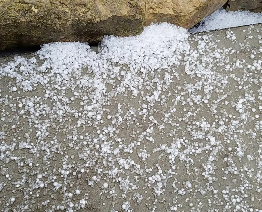
Isolated strong storms developed by mid-morning and rapidly pushed to the north, bringing hail up to dime or nickel size near Admire, Burkett — a small town 14 miles southwest of Madison — as well as Bushong and Neosho Rapids. After those storms left the area, southeastern and central Osage County were placed in a severe thunderstorm warning later in the day. No severe weather reports have been announced.
Rain fell off and on all day in Emporia and elsewhere in the KVOE listening area. The KVOE studios picked up an inch of rain from 6 pm Friday to 6 pm Saturday.
The storms were part of a massive winter storm that brought blizzard conditions and up to a foot of snow to western and central Kansas. Our next opportunity for snowfall is a slight chance Tuesday night into Wednesday.
4 pm Saturday: Rounds of thunderstorms bring hail to Lyon County, severe storm warning to Osage County
A round of strong thunderstorms brought small hail to portions of the KVOE listening area near Emporia on Saturday morning. A second round of storms triggered a severe thunderstorm warning east of Emporia Saturday afternoon.
Storm reports are pending after the warning for southeastern Osage County.
Stay with KVOE and KVOE.com for updates.
10:15 am Saturday: Small hail falls in north Lyon County; wintry mix still possible after sunset
Occasional heavy rain, fog and hail — yes, hail — have been the main weather features across the KVOE listening area Saturday morning.
And we still have some wintry weather to contend with Saturday night.
Isolated strong thunderstorms pushed rapidly to the north across Lyon, Chase, Morris and Wabaunsee counties starting around mid-morning. Dime-sized hail and smaller stones were reported by KVOE listeners in Admire and at the junction of Kansas Highway 99 and US Highway 56 shortly after 10 am.
Rain and fog were also commonplace, and have been since sunset Friday. As of 11 am, the KVOE studios received around 0.70 inches of rain since Friday evening. Fog, meanwhile, brought visibilities below a quarter-mile in some Flint Hills locations Saturday morning.
Wind advisories start at 1 pm for Chase and Greenwood counties. Wind advisories start at 4 pm for Lyon, Coffey and Osage counties. Wind gusts could top 40 mph at times through midnight.
A wintry mix is also possible from sunset to midnight areawide. Accumulations are not anticipated.
Stay with KVOE and KVOE.com for weather, travel and schedule adjustments. Link to Twitter@kvoeam1400 and Facebook@kvoenews for instant alerts if you have not already done so. If you have schedule adjustments, call KVOE at 342-1400 or email kvoe@kvoe.com.
10:15 am Saturday: Isolated strong storms, rain, high wind all part of Saturday’s weather picture
A wet afternoon is in store across the KVOE listening area.
Rain and fog have been widespread the last several hours, and we’ve even had isolated strong thunderstorms push north across Lyon, Chase, Morris and Wabaunsee counties starting around mid-morning. Storm reports are currently pending.
Wind will increase from here all the way through late Saturday night. Wind advisories start at 1 pm for Chase and Greenwood counties. Wind advisories start at 4 pm for Lyon, Coffey and Osage counties. Wind gusts could top 40 mph at times through midnight.
A wintry mix is possible from sunset to midnight areawide. Little to no accumulation is expected and resulting travel problems may well be isolated.
Click here for the latest KVOE.com Closings and Cancellations list.
7:15 am Saturday: Saturday forecast calls for damp and windy conditions for KVOE territory, blizzard conditions further west and north
For the most part, the KVOE listening area will be on the wet side of a powerful winter storm bringing blizzard conditions to western, central and northeast Kansas on Saturday.
Rain and thunderstorms are likely for much of the day after some isolated thundershower activity across the area and around 0.50 inches of rainfall, including 0.40 inches before 10 pm, at the KVOE studios Friday night into Saturday morning.
By mid-evening, we could see a brief mix of drizzle, freezing drizzle and light snow. However, all indications are the core KVOE listening area may get a dusting at most out of this winter storm — which could dump 6-10 inches of snowfall in a narrow band from Dodge City to Hays to Concordia.
Windy conditions are expected areawide. Most of the KVOE listening area could see wind gusts as high as 35 mph. Chase and Greenwood counties could have 40-mph gusts or higher, so the National Weather Service has issued a wind advisory for those counties from 1 pm to midnight.
Click here for the latest schedule adjustments on the KVOE.com Closings and Cancellations page.
Stay with KVOE and KVOE.com for weather, travel and schedule adjustments. Link to Twitter@kvoeam1400 and Facebook@kvoenews for instant alerts if you have not already done so. If you have schedule adjustments, call KVOE at 342-1400 or email kvoe@kvoe.com.
 (1)")


")