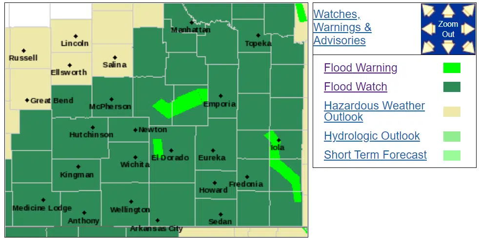
Even before the expected heavy rainfall comes to the KVOE listening area, the National Weather Service has issued river-based flood warnings west of Emporia.
The Weather Service has the Cottonwood River in warnings at Plymouth, Cottonwood Falls and Florence.
*At Plymouth, the warning goes from 10:30 am Wednesday to 7 am Friday. The river is expected to go above the 32-foot flood stage late Wednesday morning, crest at 32.9 feet early Thursday and go below flood stage Thursday evening.
*At Cottonwood Falls, the warning goes from 6 am Wednesday to 1 am Friday. The river should go above the 9-foot flood stage Wednesday morning, crest at 9.8 feet Wednesday afternoon and go below flood stage Thursday morning.
*At Florence, the warning goes from 7:30 pm Tuesday to 4 am Thursday. The river should go above the 22-foot flood stage Tuesday evening, crest at 24.1 feet Wednesday morning and go below flood stage Wednesday afternoon.
A flood watch involves Lyon, Coffey, Morris, Osage and Wabaunsee counties from 5 am Tuesday to 7 am Wednesday. There is another flood watch for Chase and Greenwood counties from 12 am Tuesday to 12 am Wednesday. The Weather Service is expecting rainfall amounts between 2-4 inches starting as soon as Monday evening. It also says isolated higher amounts are possible.
Be sure to avoid flooded areas — and if you see water covering a road, report it to authorities and turn around.
Stay with KVOE, KVOE.com and KVOE social media for updates.
3 pm Monday: Flood watches now cover all area counties
Moderate to heavy rainfall is still possible across the KVOE listening area beginning Monday night.
The National Weather Service has issued a flood watch for most area counties. Included are Lyon, Coffey, Morris, Osage and Wabaunsee counties from 5 am Tuesday to 7 am Wednesday. Earlier, the Weather Service issued a flood watch for Chase and Greenwood counties from 12 am Tuesday to 12 am Wednesday. The Weather Service is expecting rainfall amounts between 2-5 inches starting as soon as Monday evening. It also says isolated higher amounts are possible.
If the current forecast holds, this could well trigger our second round of flooding in a week. Area residents got 1.5 to 4 inches of rain May 17-18, leading to localized flooding across central Lyon County and southeast Morris County. The Lyon County Highway Department just removed barricades on the last few roads affected by last week’s flooding early Monday.
Stay with KVOE, KVOE.com and KVOE social media for updates.
Noon Monday: Lyon County’s road network finally reopens after flooding last week
Heavy rain is possible areawide to start the week, but some parts of the KVOE listening area may get more than others.
The National Weather Service has issued a flood watch for Chase and Greenwood counties from 12 am Tuesday to 12 am Wednesday. It is expecting rainfall amounts between 3-5 inches starting as soon as Monday evening. It also says isolated higher amounts are possible.
The current forecast actually indicates as much as 3-4 inches of rain are possible along and south of a line from Bazaar to Emporia to New Strawn. Areas north of that line could see 2-3 inches between Monday and Wednesday.
If the current forecast holds, this could well trigger our second round of flooding in a week. Area residents got 1.5 to 4 inches of rain May 17-18, leading to localized flooding across central Lyon County and southeast Morris County. The Lyon County Highway Department just removed barricades on the last few roads affected by last week’s flooding early Monday.
Stay with KVOE, KVOE.com and KVOE social media for updates.
10 pm Sunday: Heavy rain, localized flooding possible this week
Potentially heavy rain may be on tap for the KVOE listening area starting Monday night.
The National Weather Service is calling for anywhere from 1-3 inches of rain Monday night through Tuesday, with isolated heavier amounts possible — especially south and west of Emporia. More lingering showers are possible Wednesday.
This amount of rainfall could lead to localized flooding after area residents got anywhere from 1.5-4 inches of rain in the middle of last week, triggering flooding across central Lyon County and especially along the Neosho River from Americus through Emporia to Neosho Rapids. Just a handful of roads and intersections remain closed at this time:
*Road J north of 30th; at 215
*Road P from 140 to 150
*Road 180 from Burlingame Road to N-5
*Road 190 west of K-5
We’ll keep you updated on the rainfall and potential for flooding on KVOE, KVOE.com and KVOE social media.


