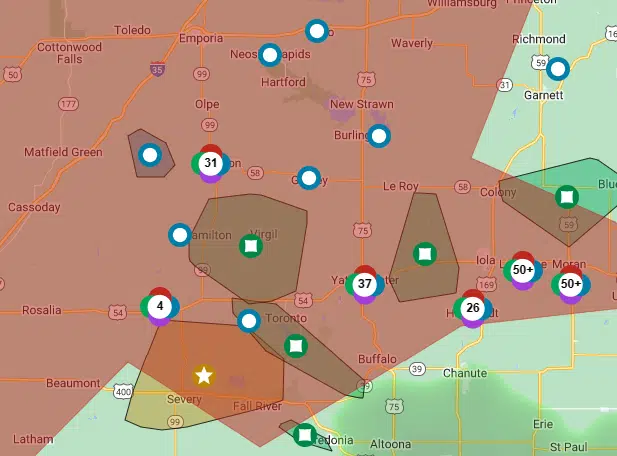
Storm activity Friday had the potential to bring damaging winds and large hail to the KVOE listening area. The storms definitely met the forecast when it came to the winds.
Wind gusts caused over 5,000 Evergy customers in Greenwood County alone to lose power at the height of the storm activity between 4-6 pm, with most — around 3,700 — north of US Highway 54, the unofficial south border of the KVOE listening area. Over 3,400 Evergy customers are still offline in Greenwood County as of 8 pm, with around 2,400 north of US-54. Greenwood County Emergency Management Director Levi Vinson says most of the damage is with line and not poles.
Evergy was also busy with small-scale outages in Emporia, Burlington, Cottonwood Falls, Gridley, Lebo and Neosho Rapids.
In all, Evergy dealt with an estimated 186,000 outages systemwide, with the most significant outage clusters in Kansas City, Lawrence and Topeka. Senor Manager of Corporate Communications Gina Penzig says company crews are working to restore power and Evergy has also reached out to utilities in neighboring states to help repair damage, but it still could take several days to get everything back to normal. Evergy teams are also out in affected areas for damage assessment.
Storms also brought heavy rainfall rates — and some heavy rain totals — to area locations:
*KVOE studios: 1 inch rainfall
*Emporia Municipal Airport: 1.08 inches rainfall
*Sixth and East: 1.4 inches rainfall
*Ninth and Arundel: 1.2 inches rainfall
*10th and Weaver: 1.27 inches rainfall
*18th and Briarcliff: 1.58 inches rainfall
*South and Sylvan: 1.6 inches rainfall
*1100 block Constitution: 1.2 inches rainfall
*Deerbrook Addition: 1.3 inches rainfall
*Allen: 1.3 inches rainfall
*Americus: 1.4 inches rainfall
*Bushong: 0.78 inches rainfall in under 40 minutes
*Eskridge: 4 inches rainfall in two hours, 1.75-inch hail
*Eureka: 4-6 inch tree limbs and utility lines downed
*Eureka Milliken Airport: 0.77 inches rainfall
*2 miles south of Hamilton: Tree limbs and utility lines downed
*Lyon County Roads 210 and K: 1 inch rainfall
*Olpe: 0.75 inches rainfall
*Reading: 1.75 inches rainfall
*1 mile east of Reading Lake: 1.6 inches rainfall
*Quincy: Tree limbs and utility lines downed
Central Lyon County, including Emporia, and portions of Morris and Wabaunsee counties were in flash flood warnings or urban and small stream flood advisories for much of the afternoon and early evening. No damage has been reported in Lyon County, although the rain’s impact on a crude oil cleanup process underway all week near Roads 300 and D has not been announced.
Large hail was isolated, with golf ball-sized hail reported in Eskridge.
2-8 pm Friday: Severe weather coverage
Strong to severe thunderstorm activity has entered the KVOE listening area:
Storm reports
*KVOE studios: 1 inch rainfall
*Emporia Municipal Airport: 0.92 inches rainfall
*10th and Weaver: 1.15 inches rainfall
*Allen: 1.3 inches rainfall
*Americus: 1.4 inches rainfall
*Bushong: 0.78 inches rainfall in under 40 minutes
*Eskridge: 4 inches rainfall in two hours, 1.75-inch hail
*Eureka: 4-6 inch tree limbs and utility lines downed
*Eureka Milliken Airport: 0.69 inches rainfall
*2 miles south of Hamilton: Tree limbs and utility lines downed
*Lyon County Roads 210 and K: 1 inch rainfall
*Olpe: 0.75 inches
*1 mile east of Reading Lake: 1.6 inches
*Quincy: Tree limbs and utility lines downed
Nearly 5,000 Evergy customers in Greenwood County, including over 3,700 in the KVOE listening area, are without power due to storms. Isolated, small-scale power outages have been reported for Evergy customers in Emporia, Burlington and Cottonwood Falls.
Schedule adjustments:
*Kansas City Royals game against Tampa Bay postponed. Double header scheduled for 1:10 pm and 6:10 pm Saturday.
*KVOE Hide and Seek remote at Flint Hills Lane postponed to Tuesday at 4:30 pm
*Reading United Methodist Church Hearts of Fire presentation postponed. New date TBD.
9 am-noon Friday: Friday severe weather risk upgraded from slight to enhanced
The severe weather risk for all area counties Friday has been upgraded.
The Storm Prediction Center went from a slight risk areawide in its early-morning update to an enhanced risk in its 7:20 am update. All hazards are possible, but 2-inch hail and 80-mph winds as part of a possible bow echo storm complex are the main threats. Storms are possible from mid-afternoon to mid-evening in the current forecast.
Storms will overlap typical summertime heat and humidity. High temperatures are expected in the low 90s with heat index readings in the mid- to upper 90s by late afternoon.
Be sure to stay with KVOE, KVOE.com and KVOE social media for updates. If you haven’t already connected to KVOE’s social media channels, find us on Facebook, Instagram and YouTube — all @kvoenews — and on Twitter@kvoeam1400.
5:20 am Friday: Slight severe weather risk develops by mid-afternoon Friday
Another day of typical summer heat and storms is ahead for the KVOE listening area.
High temperatures will reach the low 90s by late afternoon with heat index readings in the mid-90s. By mid- to late afternoon, storms should move in from the northwest. All area counties are in a slight risk area for the risk of wind and hail, but there is a chance storms in Oklahoma could suck up the available incoming moisture and thus limit any chance for severe storms by mid-afternoon.
The weekend forecast calls for seasonal weather conditions, meaning highs in the low- to mid-90s both Saturday and Sunday and a slight chance of storms Sunday.
Stay with KVOE, KVOE.com and KVOE social media for updates.


