


After light to moderate rain totals Sunday, attention turns to the potential for severe weather across much of the Central and Southern Plains on Monday.
Heavier showers and embedded thunderstorms lost their steam as they moved south to north towards Emporia on Sunday morning, leading to reduced rain totals north of Greenwood County:
*KVOE studios: 0.10 inches
*Emporia Municipal Airport: 0.14 inches
*Neosho Rapids: 0.25 inches
*Eureka Lt. William Milliken Airport: 0.50 inches
Humid conditions are in place as we get into Monday, including a dense fog advisory for Greenwood County from 4-9 am. Visibility could be a quarter-mile or less, meaning drivers need to slow down, use their low-beam headlights and increase the driving distance between their vehicles and others nearby.
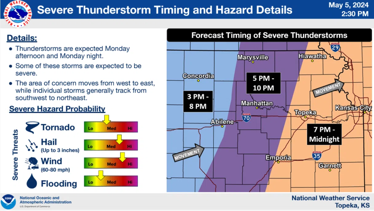
Monday’s forecast involves a widespread risk of severe weather across Kansas and several nearby states, and both the National Weather Service and Storm Prediction have been using the phrase “potential severe weather outbreak” for several days now. The greatest risk area remains a moderate risk, or Level 4 on the SPC’s five-point scale, for south central Kansas into much of western Oklahoma. Most of Kansas, including the entire KVOE listening area, is in an enhanced risk, or Level 3. The full KVOE listening area could see damaging winds up to 80 mph and a few strong tornadoes, while areas along and west of a line from Alma to Emporia to Eureka could see hail to the size of baseballs.
The most recent guidance indicates severe storms will move into the KVOE listening area west to east by early evening and exit by midnight. There are still concerns about the storm mode as activity approaches the area. Isolated or separated supercells typically increase the risk of tornadic activity, while lines or line segments push the main risk into a wind/hail event while diminishing concerns about strong tornadoes.
Regardless, meteorologists and emergency management staffers are advising residents to review their severe weather safety plans and be ready to activate those plans Monday.
Be sure to stay with KVOE, KVOE.com and KVOE social media for updates. If you haven’t already joined KVOE social media channels, find KVOE on Facebook@kvoenews, Instagram@kvoenews, YouTube@kvoenews and X@kvoeam1400.
6 am Sunday: Enhanced all-hazard severe storm risk in place Monday
Showers and thunderstorms are possible Sunday. They should not be severe.
Showers and storms are now likely for Monday late afternoon through late evening, and those well could be severe. In fact, the National Weather Service offices in Topeka and Wichita, along with the Storm Prediction Center, have been mentioning concerns about a potential severe weather outbreak Monday, and the latest guidance still bears those concerns. Storms could bring very large hail, damaging wind and a few tornadoes to the KVOE listening area for the evening hours.
An enhanced risk, or Level 3 on the Storm Prediction Center’s five-point scale, involves all area counties in Monday’s forecast. A moderate risk, or Level 4, covers south central Kansas and much of western Oklahoma.
The NWS offices and SPC say this has the potential to be a higher-level event, but there are some possible limiting factors, especially low-level wind shear — or winds in different directions as air parcels climb further from ground level — and storm interactions.
 (1)")


")