


Severe weather is possible across most of Kansas, including all area counties, for Saturday evening.
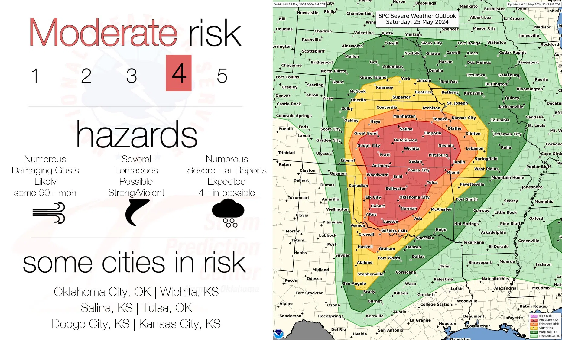
The Storm Prediction Center has issued a moderate risk, or Level 4 on its 5-point scale, for all hazards. Currently, the National Weather Service Topeka office says the main concerns are for wind gusts 75 mph or greater, resembling the wind speeds that caused tree damage Sunday night. Egg-sized hail or larger and scattered tornadoes are possible, although the main tornadic risk is in central and south-central Kansas.
Area counties also have at least a low-level risk of flash flooding.
11 am Friday: Enhanced severe storm risk ahead for late afternoon through evening Saturday
Strong to severe thunderstorms are possible for part of the upcoming Memorial Day holiday weekend.
The main risk is late Saturday afternoon through early Sunday morning, with wind gusts up to 80 mph — similar to this past Sunday — for all area counties. Quarter- to baseball-sized hail, with larger hail especially west of Kansas Highway 177, and isolated tornadoes are also possible.
The Storm Prediction Center has all area counties in an enhanced risk area for Saturday into early Sunday.
Storms should push out of the KVOE listening area Sunday morning, but the Storm Prediction Center still has a marginal severe weather risk for areas along and east of a line from Harveyville to Reading to Gridley. All hazards are officially possible but unlikely.
Memorial Day looks to be sunny and dry with high temperatures around 80 degrees.
With the severe weather risk developing for the first part of the holiday weekend, be sure to stay with KVOE, KVOE.com and KVOE social media for updates. Also, be sure to connect to KVOE’s social media channels if you haven’t already done so — Facebook, Instagram and YouTube, all @kvoenews, and X@kvoeam1400.
6:15 am Friday: Thursday/Friday storm chances yield little activity
Isolated storm activity brought one confirmed severe weather report Thursday evening with the potential for more activity coming through much of Saturday.
Storms moved into the listening area around 8 pm Thursday and triggered a single thunderstorm warning affecting the eastern portion of Chase County. KVOE received two reports of hail between 1.25 and 1.5 inches in Americus.
Storm chances return to the listening area Saturday afternoon with all hazards possible including damaging winds, large hail and isolated tornadoes. An enhanced risk covers the entire listening area into the evening hours with a chance for more isolated storm activity on Sunday.
KVOE, KVOE.com and KVOE social media will have updates as needed throughout the weekend.
*Click here for KVOE’s YouTube channel, including video from Thursday night.
 (1)")


")