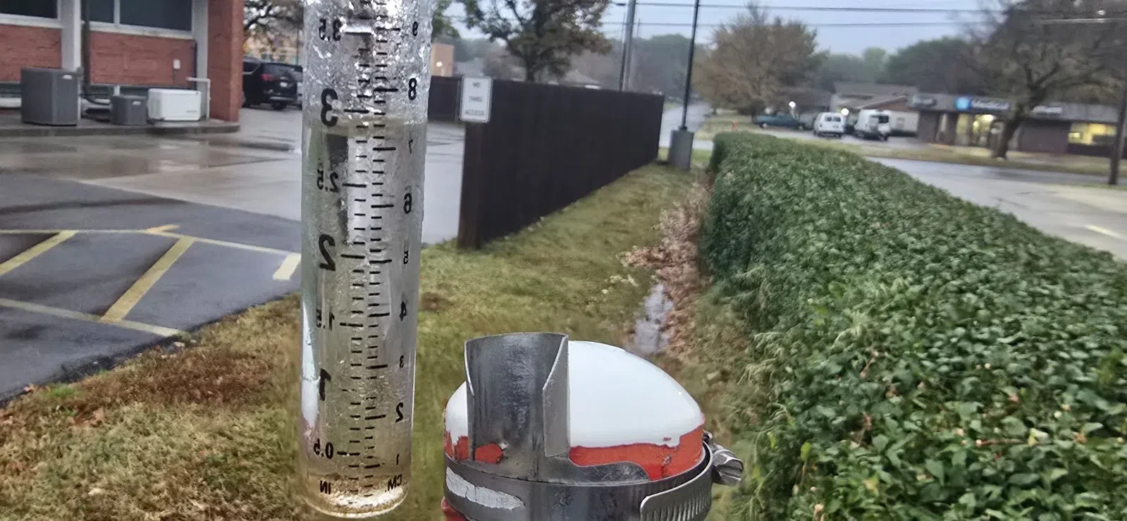
Widespread flooding was not a major concern before heavy extended rainfall began but it is now.
Several advisories are now in place effecting all area counties including a flood watch for Lyon, Chase, Coffey, Greenwood, Morris and Osage counties until midnight Monday. An urban and small stream flood advisory is also in place for northwest Lyon and southern Wabaunsee counties until 9:30 pm.
The local deluge has led to reports of flooding across the area and has closed several roads in Lyon County. Barricades have been placed at the following locations:
*Road 150 and J southbound
*Road 140 and J north and eastbound
*Road 140 and K east and westbound
*Road 140 and South Kansas Highway 99 westbound
*Road 150 from N to P
*Road R and 160
Drivers are reminded that it is illegal to drive around barricades and if they come across a road with water over it, whether barricades are up or not, to turn around don’t drown.
Moderate to heavy rainfall began just before sunrise Saturday and continued uninterrupted through the afternoon and finally began to let up by the early evening hours. At the KVOE studios, we received 3 inches of rainfall.
Additional rain reports include:
*2.3 inches on Willow Lane
*2.74 inches at Country Club Heights
*2 inches on Burns
*2.1 inches in the 1500 block of Prairie Street
*3.2 inches 1.5 miles east of Thorndale.
If you have rain totals to report please message the Bluestem Farm and Ranch Supply text line at 620-342-5863 or email KVOE@KVOE.com.
The extended period of rainfall is forecasted to continue through the remainder of the weekend into the upcoming work week with NWS calling for an additional 1-3 inches of rainfall with higher totals in the east-central region of the state. There is also a chance of thunderstorms Sunday, however, continued cloud cover has reduced the chances for severe activity across the area after there was at one time a marginal risk in place.
This is the first significant rainfall the area has seen in well over a month which could have a positive impact on drought conditions that have been deepening in recent weeks.
Be sure to stay with KVOE, KVOE.com and KVOE social media for more weather updates as they develop over the remainder of the weekend.
2:15 pm Saturday:
Heavy rainfall areawide has led to some flooding and a number of flood alerts.
Active alerts
*Urban and small stream flood advisory: Central Lyon County until 5 pm. Incudes Emporia.
*Flood warning: Southwest Chase County until 3:30 pm
*Flood watch: Lyon, Chase, Coffey, Greenwood, Morris and Osage counties until 12 am Sunday
Rainfall totals of 2-plus inches Saturday are commonplace across Lyon and surrounding counties after half an inch to 3 inches of rain Wednesday. Another 1-4 inches of rain are possible areawide through Monday night.
1:30 pm Saturday: Handful of Lyon County roads south of Emporia now closed due to flooding
Lyon County Emergency Communications is listing a handful of county roads closed due to flooding:
*Road J between 140 and 150
*Road 140 between J and K
*Road 140 westbound from Kansas Highway 99
In Emporia, Trowman Way was reported as flooded before noon by street residents.
Whenever you encounter flooded roads, turn around and find another way to your destination.
Stay with KVOE, KVOE.com and KVOE social media for updates.
1 pm Saturday: Flooding reported on Trowman Way; southwest Chase County in flood warning
Persistent rainfall has apparently flooded one Emporia street.
Residents tell KVOE News Trowman Way flooded before noon. The city has been advised.
Soils are rapidly getting saturated after 0.5-3 inches of rainfall Wednesday and what appears to be an extended risk of rainfall through at least Monday night. Rain totals through 12:30 pm Saturday:
*KVOE studios: 2.50 inches
*Emporia Municipal Airport: 2.39 inches
*Country Club Heights: 1.82 inches
*Willow Lane: 2.30 inches
*10th and Burns: 2 inches
*1500 block Prairie: 2.10 inches
Chase County is in a flood watch until 10 pm Saturday, while southwest Chase County is in a flood warning until 3:30 pm. Area rivers are rising slowly and are nowhere close to flood stage as of 12:45 pm.
Stay with KVOE, KVOE.com and KVOE social media for updates. If you have rain totals or flood reports, message the Bluestem Farm and Ranch Supply text line at 620-342-5863.
8:30 am Saturday: Widespread flooding concerns could increase as heavy to moderate rainfall continues
Widespread flooding is not of the utmost concern at least as of now, however, that could change as moderate to heavy rainfall continues through the weekend.
Rainfall began Saturday morning just before sunrise and dumped an inch of rain in the KVOE rain gauge by 9:30 am. If you have rain totals to report please message the Bluestem Farm and Ranch text line at 620-342-5863 or email KVOE@KVOE.com.
The rainfall has already led to a pair of flood-related advisories within the KVOE listening area, specifically in Chase County. A flood watch covers the majority of Chase now until 10 pm with a flood warning in place for the southwestern corner of the county until 3:30 pm.
Thus far there have been no reports of flooding within the county.
According to National Weather Service Meteorologist Sarah Teefey, there is not a large concern for widespread flooding across the area at this time but that could change if the rainfall continues at this pace for the next few days as expected.
In addition to the rainfall, scattered thunderstorms are expected now through Monday evening, however, the threat of severe activity, previously in the marginal category for the entire listening area, has decreased as of Saturday morning. Teefey says the rainfall and cloud coverage have had something to do with that.
Current forecasts are still calling for anywhere between 1-4 inches of rainfall between now and Monday with higher totals, 3-6 inches, possible in the east-central portion of the state. Be sure to stay with KVOE, KVOE.com and KVOE social media for more weather updates as they develop.
8:30 am Saturday: WEATHER: Heavy rainfall now underway across KVOE listening area; Flood alerts up for portion of KVOE listening area
Heavy, scattered rainfall has begun for the KVOE listening area and will continue through the weekend into the early portion of the work week.
Rainfall began just before sunrise Saturday and has already led to a pair of flood-related advisories for Chase County. A flood watch is in place for the majority of Chase through Saturday evening, while a flood warning goes for the southwestern corner of Chase now through 3:30 p.m.
The National Weather Service is still calling for anywhere between 1 and 4 inches of rainfall across the area, which could lead to elevated rivers and streams. Currently, we have 0.40 inches of rainfall in the KVOE rain gauge.
If you have rain totals to report please message the Bluestem Farm and Ranch text line at 620-342-5863 or email KVOE@KVOE.com.
There is also a chance for scattered thunderstorms throughout the next few days, however, severe storm potential which was marginal for Sunday has been lowered to non-severe levels.


