


Once again, flood warning information has adjusted as two area river gauges remain in flood.
The Cottonwood River at Emporia is now in a flood warning until shortly before 5:30 am Thursday. It reached 22.84 feet Tuesday afternoon and has dropped slightly since then. It should go below the 20-foot flood stage before noon Wednesday.
For the Neosho at Neosho Rapids, the flood warning is now set to end at 5 am Thursday. The river is set to crest at 22.8 feet early Wednesday morning and go below the 22-foot flood stage before noon.
Additional information can be found below.
4:30 pm Tuesday:
Flood warnings and road closures continue across parts of Lyon County after anywhere from 1.5-5 inches of rainfall this past weekend.
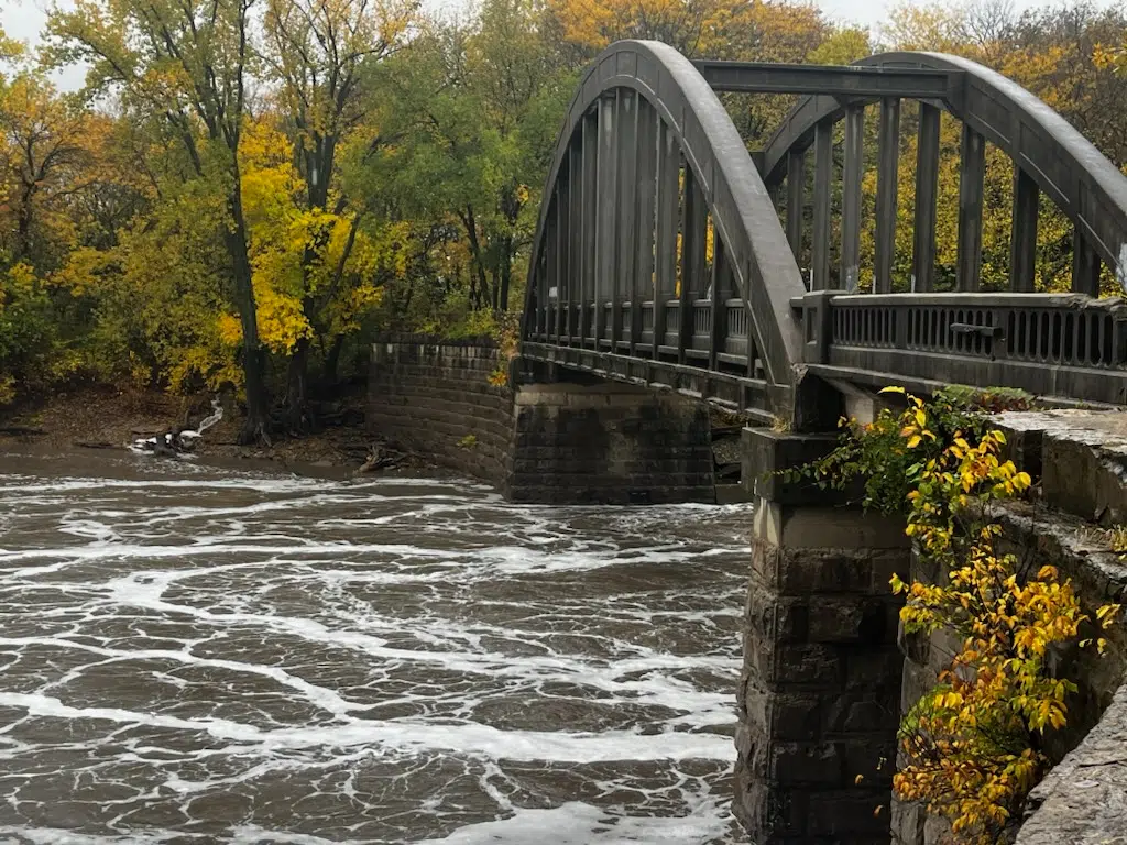
A flood warning continues for the Cottonwood River at Emporia until 2 pm Wednesday. The river has been above the 20-foot flood stage since Monday afternoon and has been as high as 22.82 feet early Tuesday afternoon, above an earlier crest projection of 22 feet. The river is now supposed to rise to 23 feet later Tuesday and fall below flood stage early Wednesday afternoon. 23 feet is where the north bank floods, causing lowland flooding from Neosho Rapids west to Plymouth. The river should stay below 24 feet, where water gets onto Kansas Highway 99.
Meanwhile, the Neosho River at Neosho Rapids is now in a flood warning until 10 am Wednesday. The river is currently at 22.33 feet, just above flood stage of 22 feet, and expected to crest at just below 23 feet. At that level, water overtops Road 145 on the west side of a bridge near the river.
No other flood alerts are currently expected areawide.
Several roads remain closed in central and southern Lyon County, and Assistant County Engineer Jim Brull says crews were busy both during and after the holiday weekend.
There will likely be updates to Lyon County’s road closure list this week:
*Road 150 between between Roads J Kansas Highway 99
*Road 155 between Roads F-5 and G
*Road 160 between Roads N and P
*Road K between Roads 140 and 150
*Road J between Roads 140 and 160
Roads closed Tuesday:
*Road 150 between Roads E and F; between Roads W and X
*Road 160 between Roads G and J
*Road F between Roads 150 and 160
Reopened are the following road segments:
*Road 30 west of Kansas Highway 99
*Road 140 between Roads F and H
*Road 145 between Roads F and H
*Road 150 from Roads H to J; between Roads N and P
*Road 170 between Roads M and P
*Road H between Roads 140 and 150
*Road G between Roads 140 and 150
*Road N north of Road 170
*Road P between Roads 160 and 170
KVOE and KVOE.com will have updates on river readings and road closures until things return to normal.
10:50 am Tuesday: Cottonwood River remains in flood near Emporia; flood warning posted for Neosho River at Neosho Rapids
Flood issues persist in central and southern Lyon County after heavy rainfall for the Memorial Day weekend.
A flood warning continues for the Cottonwood River at Emporia until Wednesday evening. The river has been above the 20-foot flood stage since Monday afternoon and has been as high as 22.56 feet early Tuesday, above an earlier crest projection of 22 feet. The river is now supposed to rise to 23 feet later Tuesday and fall below flood stage early Wednesday morning. 23 feet is where the north bank floods, causing lowland flooding from Neosho Rapids west to Plymouth. The river should stay below 24 feet, where water gets onto Kansas Highway 99.
Meanwhile, the Neosho River at Neosho Rapids is now in a flood warning until early Wednesday afternoon. The river is currently at 21.8 feet, just below flood stage of 22 feet, and expected to crest at just below 23 feet. At that level, water overtops Road 145 on the west side of a bridge near the river.
No other flood alerts are currently expected areawide.
National Weather Service meteorologist Chelsea Picha tells KVOE News the pattern is getting more settled, even with a few chances of more rain the next two days.
It also appears any incoming rainfall will be in the form of showers and not thunderstorms. Picha says there is not much instability in the atmosphere, either currently or later in the week.
Weekend rain totals have been impressive:
*KVOE studios: 1.50 inches Monday, 3.80 inches total
*Emporia Municipal Airport: 1.30 inches Monday, 2.03 inches total
*Seventh and Market: 4 inches total
*Ninth and Lawrence: 1.15 inches Monday, 1.48 inches total
*10th and Weaver: 3.20 inches total
*300 block Arundel: 3 inches total
*1100 block Constitution: 3.80 inches total
*Country Club Heights: 1.10 inches Monday, 3.45 inches total
*7 miles southwest of Emporia: 7-plus inches since May 19
*3.5 miles west of Emporia Golf Course: 8 inches since May 19
*Allen: 3 inches total
*Americus: 4.25 inches total
*5 miles southwest of Olpe: 4 inches total
There will likely be updates to Lyon County’s road closure list Monday. The current list reads as follows:
*Road 30 west of Kansas Highway 99
*Road 140 between Roads F and H
*Road 145 between Roads F and H
*Road 150 between between Roads H and Kansas Highway 99; between Roads N and P
*Road 155 between Roads F-5 and G
*Road 160 between Roads N and P
*Road 170 between Roads M and P
*Road G between Roads 140 and 150
*Road H between Roads 140 and 150
*Road K between Roads 140 and 150
*Road J between Roads 140 and 160
*Road N north of Road 170
*Road P between Roads 140 and 150; between Roads 160 and 170
*Burlingame Road at Riley Avenue for southbound traffic only
Rain also led to several injury crashes on highways near Emporia:
*One person was taken to Newman Regional Health after a crash on the Kansas Turnpike at mile marker 116.5 southbound, a little more than 10 miles southwest of the Emporia gate. 38-year-old Troy Hitesman of Topeka was driving an SUV southbound when it hydroplaned and went into a ditch. He suffered potential injuries.
*Two people were taken to Newman Regional Health after a crash less than 10 minutes later and just over a mile closer to Emporia. The wreck at mile marker 117.7 southbound involved an SUV that also hydroplaned. Two people from Fort Worth, Texas, 70-year-old Robin Keehn and 71-year-old Patricia Keehn, were hospitalized.
*One person was taken to Newman Regional Health after an eastbound semi tipped over on US Highway 50 between Overlander Road and the south roundabout connecting the highway to Interstate 35 and the Turnpike. Additional details about that crash are pending.
If you have rain reports or road flooding to report, call KVOE at 620-342-1400 or message the KVOE Bluestem Farm and Ranch text line at 620-342-5863.
5 pm Monday: Cottonwood River now in flood at Emporia
As rain amounts increase, rivers are rising areawide.
One gauge, the Cottonwood River at Emporia, is now in a flood warning until 3 pm Tuesday after initially expiring at 1 pm Tuesday. The river went into flood shortly before 4 pm and is now expected to crest right at 20.5 feet, just above flood stage of 20 feet. The river could go back below flood stage by Tuesday afternoon if there is no additional rain.
Other gauges are on the rise.
*The Neosho River at Emporia has tentatively crested about six feet below the 19-foot flood stage, while the river at Neosho Rapids is projected to crest just below flood stage of 20 feet. At Americus, the river tentatively crested a little over 10 feet below flood stage of 21 feet.
*The Cottonwood River at Plymouth is above 29 feet, rising but below flood stage of 32 feet. It is near 7 feet at Cottonwood Falls and climbing towards flood stage of 9 feet. The river has tentatively crested at 13.1 feet, nearly 7 feet below flood stage, at Florence.
*The Marais des Cygnes River above Reading has tentatively crested near 6 feet, below flood stage of 19 feet.
The KVOE studios have picked up 1.3 inches of rain between midnight and noon Monday after 2.5 inches of rain earlier in the Memorial Day weekend. Other totals:
*Emporia Municipal Airport: 1 inch Monday, 1.63 inches weekend total
*3.5 miles west of Emporia Municipal Airport: 2.4 inches weekend total, 8 inches since May 19
*Ninth and Lawrence: 1.1 inches Monday, 1.43 inches weekend total
*Lamont: 4 inches weekend total


