


A pair of local rivers remain under flood warnings, one through Wednesday evening and the other through early Friday, with additional rainfall expected through Thursday evening.
The National Weather Service is anticipating another 0.5 inches to 1.5 inches of rainfall in that time frame. As mentioned, two flood warnings remain in place for separate rivers in the area:
The Cottonwood at Emporia is now out of a flood warning after cresting Tuesday at 22.84 feet. If the current forecast holds, the river may go back into flood late Friday morning, crest near 22 feet Saturday morning — almost two feet above flood stage — and go back below flood stage later Saturday.
*Click here for KVOE News’ prior coverage.
Find more information below.
Second round of flooding now expected for Cottonwood at Emporia, Neosho at Neosho Rapids with more rain starting Wednesday night; Cottonwood at Florence now in flood warning
Both the Cottonwood River at Emporia and Neosho River at Neosho Rapids remain in separate flood warnings until later Wednesday, but the rivers could well go back out of their banks if the current weather forecast holds.
*The Cottonwood at Emporia is now in a flood warning until 3:30 pm Wednesday. The river has been above the 20-foot flood stage since Monday afternoon and crested Tuesday at 22.84 feet. Minor flooding continues with the river at 21 feet and set to fall below flood stage early Wednesday afternoon. With more rain expected, the river is now expected to go back into flood late Friday morning, crest around 21.9 feet Saturday morning and go back below flood stage later Saturday.
*The Neosho at Neosho Rapids is now in a flood warning until 8 pm Wednesday. The river is in moderate flood at 23 feet, above flood stage of 22 feet and just below a tentative crest at 23.13 feet. The river should go below flood stage Wednesday evening before possibly going back above flood stage early Saturday. The river could rise to 22.6 feet Saturday afternoon and go back below flood stage early Sunday.
The National Weather Service has also issued a flood warning for the Cottonwood at Florence affecting western Chase County into Friday afternoon. The river is now under 6 feet but is expected to go above the 22-foot flood stage late Thursday morning and crest at 23.6 feet Thursday evening. The river should go below flood stage Friday morning.
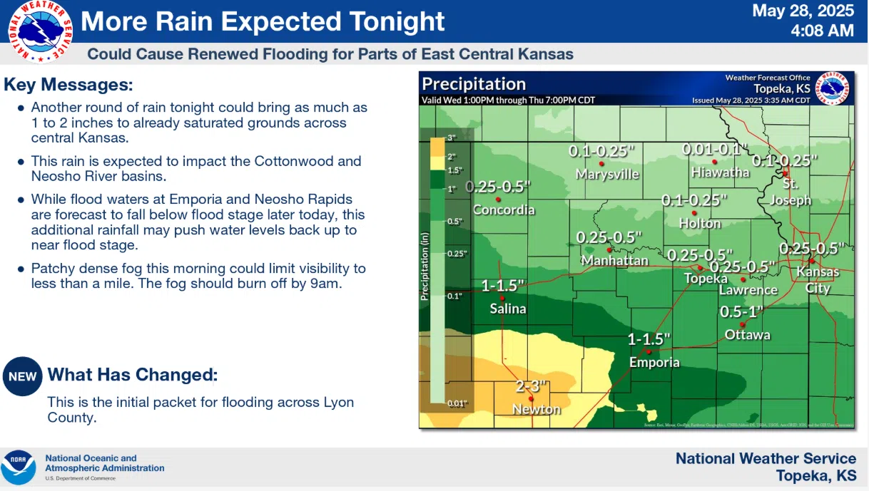
Showers could bring occasionally heavy rain to the KVOE listening area Wednesday night through much of Thursday. Upwards of 1.5 inches of rain are possible areawide, with areas further west and feeding into the Cottonwood and Neosho river basins possibly getting another 2-3 inches of rain after heavy rain through the Memorial Day weekend.
Find more information below.
7 am Wednesday: Occasional heavy rain Wednesday night comes with two Lyon County river gauges projected to come out of flood
After anywhere from nearly 1.5-5 inches of rain through the Memorial Day weekend, it appears we have one more chance of moderate to heavy rainfall in the short-term forecast.
The National Weather Service says we could see 0.5-1.5 inches of more rainfall through early Thursday evening, but areas further west along the Cottonwood River basin could get 2 inches or more — thus pushing the Cottonwood and Neosho rivers back close to flood stage possibly by Friday.
Both the Cottonwood River at Emporia and Neosho River at Neosho Rapids remain in separate flood warnings until early Thursday morning:
*The Cottonwood at Emporia has been above the 20-foot flood stage since Monday afternoon and crested Tuesday at 22.84 feet. Minor flooding continues with the river at 21.40 feet and set to fall below flood stage early Wednesday afternoon.
*The Neosho at Neosho Rapids is in moderate flood with the river at 23.13 feet, above flood stage of 22 feet. Water is now on Road 145 on the west side of a bridge near the river. The river should crest at 23.3 feet Wednesday morning, and the current projection has the river going below flood stage before noon.
Several Lyon County roads remain closed after the holiday weekend rainfall, and there will likely be updates to Lyon County’s road closure list this week. Assistant County Engineer Jim Brull reminds drivers to heed the barricades in place, even though they may cause notable travel adjustments.
Lyon County Highway Department kept several roads closed Tuesday, closed several others and opened a few as part of a busy day.
Ongoing road closures:
*Road 150 between between Roads J Kansas Highway 99
*Road 155 between Roads F-5 and G
*Road 160 between Roads N and P
*Road K between Roads 140 and 150
*Road J between Roads 140 and 160
Roads closed Tuesday:
*Road 150 between Roads E and F; between Roads W and X
*Road 160 between Roads G and J
*Road F between Roads 150 and 160
Reopened are the following road segments:
*Road 30 west of Kansas Highway 99
*Road 140 between Roads F and H
*Road 145 between Roads F and H
*Road 150 between Roads H and J; between Roads N and P
*Road 170 between Roads M and P
*Road H between Roads 140 and 150
*Road G between Roads 140 and 150
*Road N north of Road 170
*Road P between Roads 160 and 170
KVOE and KVOE.com will have updates on river readings and road closures until things return to normal. Click here for KVOE News’ coverage from earlier this week and the Memorial Day weekend.


