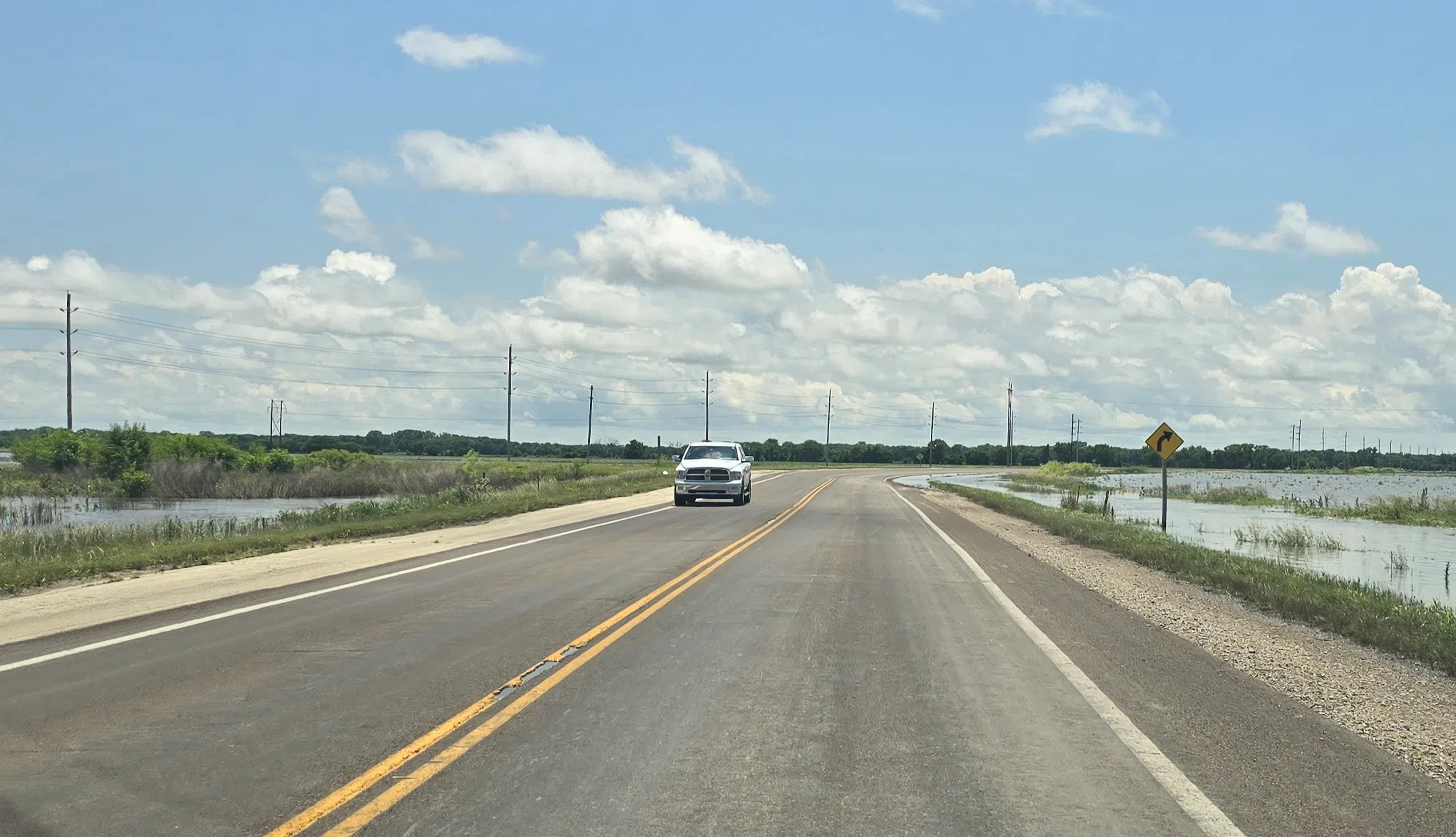
Kansas Highway 99 south of Emporia is back open to traffic.
The Kansas Department of Transportation reopened the roadway for the first time since midweek after torrential rainfall led to major flooding across the area, forcing the closure of the highway. KDOT had said previously the road was likely to reopen at some point Saturday, however, additional rainfall between Friday and Saturday put those plans in question, however, KDOT Engineer Steve Baalman says the overnight precipitation was far from enough to alter said plans.
There is still a chance for additional showers and storms between Saturday and Sunday, including a marginal to slight severe weather risk Sunday into Monday. With that in mind, KVOE News asked Baalman if there are concerns the highway’s reopening may be short-lived. He says any rain totals that may come with those storms will likely not lead to another round of significant flooding that would require the highway to be closed again.
Between Friday and Saturday, the KVOE studios received an additional 1.3 inches of rainfall bringing our week total to roughly six inches total. Other area rain totals included:
*Burns: 2 inches
*Ninth and Burns: 1.1 inches
*Hammond Heights: 1.2 inches
*Sonora Drive: 1.5 inches
*1100 Block of Constitution: 1.35 inches
*8 miles southwest of Emporia: 2.75 inches
*2 miles north of Lebo: 2 inches
*Allen: 1.7 inches
*Northeast of Council Grove: 2.95 inches
*Neosho Rapids: 3.2 inches
*Strong City: 3 inches
While the highway is set to reopen, several local roads remain closed and barricaded at this time.
Lyon County Road Closures:
*Road 50 from Highway 99 to Road R
*Road 130 between Road H and Road F
*Road 140 between Road J and Kansas Highway 99
*Road 150 between Roads D and F; between Road K and Kansas Highway 99; between Roads M and N; between Roads W and X
*Road 160 from Road N to Road R
*Road 170 from Road M7 to Road R1; from Road Y to Road Z
*Road 165 from Road M to Road N
*Road 190 from Burlingame Road to Road L5
*Road 200 from Road R to Road S
*Road 225 from Road F to Road F5
*Road 240 from C to the Americus City Limits
*Road 250 from Road D to Road E; from Road H-5 to Road J-7
*Road 260 from Road D to Road E; from Road G to Road H-5
*Road 270 from Road D to Road F
*Road A from Highway 50 to Road 180
*Road B-2 from US Highway 50 to Road 175
*Road B-5 from US Highway 50 to Road 175
*Roac C from US Highway 50 to Road 175
*Road D from Road 260 to 270
*Road E from 260 to 270
*Road F from 225 to 235
*Road J between Roads 140 and 160; between Roads 240 and 250
*Road K between Roads 130 and 150
*Road M from Road 190 to Road 197
*Road N from Road 160 to Road 170
*Road P from Road 40 to Road 60; from Road 150 to Road 170
*Road R from Road 150 to Road 170
Chase County road closures:
*Lake Rd between Cottonwood Falls and Elmdale
*Road B in Cedar Point north and south of Hwy 50
*N Rd south of Lake Rd
*Camp Wood Rd in Elmdale
*170th and B Rd north of Hwy 50 in Cedar Point
*88th Rd in Cedar Point
*G Rd south of Hwy 50 in Clements
*PR Rd Cottonwood Falls
*YY Rd north and south of Hwy 50
*XX Rd north and south of Hwy 50
*Norton Creek Rd Bazaar
*Sharps Creed Rd Bazaar
*U Rd and Old Hwy 50, Strong City
*LP Rd
*Middle Creek Rd
*Diamond Creek Rd
*South Cottonwood St in Strong City
Also, while the flood waters are beginning to subside, flood warnings are still in place for a pair of area river gauges:
*The Cottonwood at Emporia remains in a flood warning until Monday morning with moderate flooding still underway. The river was last observed at 24.2 feet, or nearly five feet above the 20-foot flood stage. The current forecast has the river going below flood stage by early Sunday afternoon.
*The Neosho River at Neosho Rapids is in a flood warning until early Tuesday morning as moderate flooding continues. The river was last observed at 25.3 feet, a little more than three feet above the 22-foot flood stage. The river is supposed to go below flood stage Sunday evening.
Stay with KVOE, KVOE.com and KVOE social media for more updates on the flooding situation as they develop.
9 am Saturday: FLOODS: Kansas Highway 99 remains closed south of Emporia; Flood warnings extended to Monday following latest round of rainfall Friday into Saturday
Plans for reopening Kansas Highway 99 south of Emporia are unclear at this time following the latest round of storm activity between late Friday and early Saturday.
Plans were to reopen the roadway by sometime on Saturday, originally; however, it is unknown at this time if that will still happen. KVOE News has reached out to the Kansas Department of Transportation for an update on the situation.
*Hammond Heights: 1.2 inches
*8 miles southwest of Emporia: 2.75 inches
2 am Saturday: FLOODS: Flash flood warning for west central Lyon County dovetails with extensive power outage
Ongoing flooding may well be aggravated for much of the KVOE listening area.
Thunderstorms crossing the area late Friday night and very early Saturday morning triggered a flash flood warning for west central Lyon County, including Emporia. The warning follows an estimated 1.5-2.5 inches of rain and measured totals of over 1 inch from thunderstorm activity.
As of 1 am Saturday, two area river gauges remain in flood after 3-7 inches of rain Tuesday.
*The Cottonwood at Emporia remains in a flood warning until late Monday morning with moderate flooding still underway. Before the flash flood warning, the river was at 24.79 feet, or nearly five feet above the 20-foot flood stage. The current forecast has the river going below flood stage Sunday evening, but it does not include the effects of the flash flood warning.
*The Neosho River at Neosho Rapids is in a flood warning until early Monday morning as moderate flooding continues. Before the flash flood warning, the river was at 25.14 feet, or more than three feet above the 22-foot flood stage. The river is supposed to go below flood stage Sunday evening, but the current forecast does not factor in the flash flood warning.
Plans were mentioned to reopen Kansas Highway 99 south of Emporia on Saturday. Adjustments to that plan are pending. Other Lyon County road closures:
*Road 50 from Highway 99 to Road R
**Road 130 between Road H and Road F
*Road 140 between Road J and Kansas Highway 99
*Road 150 between Roads D and F; between Road K and Kansas Highway 99; between Roads M and N; between Roads W and X
*Road 160 from Road N to Road R
*Road 170 from Road M7 to Road R1; from Road Y to Road Z
*Road 165 from Road M to Road N
*Road 190 from Burlingame Road to Road L5
*Road 200 from Road R to Road S
*Road 225 from Road F to Road F5
*Road 240 from C to the Americus City Limits
*Road 250 from Road D to Road E; from Road H-5 to Road J-7
*Road 260 from Road D to Road E; from Road G to Road H-5
*Road 270 from Road D to Road F
*Road A from Highway 50 to Road 180
*Road B-2 from US Highway 50 to Road 175
*Road B-5 from US Highway 50 to Road 175
*Roac C from US Highway 50 to Road 175
*Road D from Road 260 to 270
*Road E from 260 to 270
*Road F from 225 to 235
*Road J between Roads 140 and 160; between Roads 240 and 250
*Road K between Roads 130 and 150
*Road M from Road 190 to Road 197
*Road N from Road 160 to Road 170
*Road P from Road 40 to Road 60; from Road 150 to Road 170
*Road R from Road 150 to Road 170
Chase County road closures:
*Lake Rd between Cottonwood Falls and Elmdale
*Road B in Cedar Point north and south of Hwy 50
*N Rd south of Lake Rd
*Camp Wood Rd in Elmdale
*170th and B Rd north of Hwy 50 in Cedar Point
*88th Rd in Cedar Point
*G Rd south of Hwy 50 in Clements
*PR Rd Cottonwood Falls
*YY Rd north and south of Hwy 50
*XX Rd north and south of Hwy 50
*Norton Creek Rd Bazaar
*Sharps Creed Rd Bazaar
*U Rd and Old Hwy 50, Strong City
*LP Rd
*Middle Creek Rd
*Diamond Creek Rd
*South Cottonwood St in Strong City
The late-Friday and early-Saturday storms have caused another issue. Over 1,100 Evergy customers have been offline from southwest Emporia to Clements due to storm activity, although virtually all those outages were restored by 2 am. Over 360 4 Rivers customers in Lyon and Chase counties were affected, along with nearly 40 Flint Hills Rural Electric Cooperative customers in Chase and Morris counties.
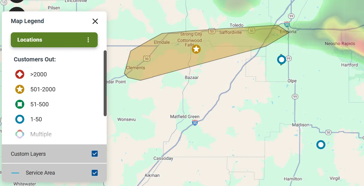
Evergy map.
The flooding impacts have been notable earlier in the week. Along with several water rescues, Saffordville was underwater for at least a day and southern access to Plymouth has been cut off for much of the week. Speaking of access, the flood-related closure of Camp Wood Road kept over 280 campers and staff at Camp Wood YMCA without a major way to depart. CEO BJ Murray says camp leadership had conversations with the Chase County Highway Department as Camp Wood Road was being repaired. The process was finished Friday. Murray also says supplies were starting to run low shortly before Camp Wood Road reopened, but arrangements have been made to resupply the camp soon.
KVOE and KVOE.com will have updates.