



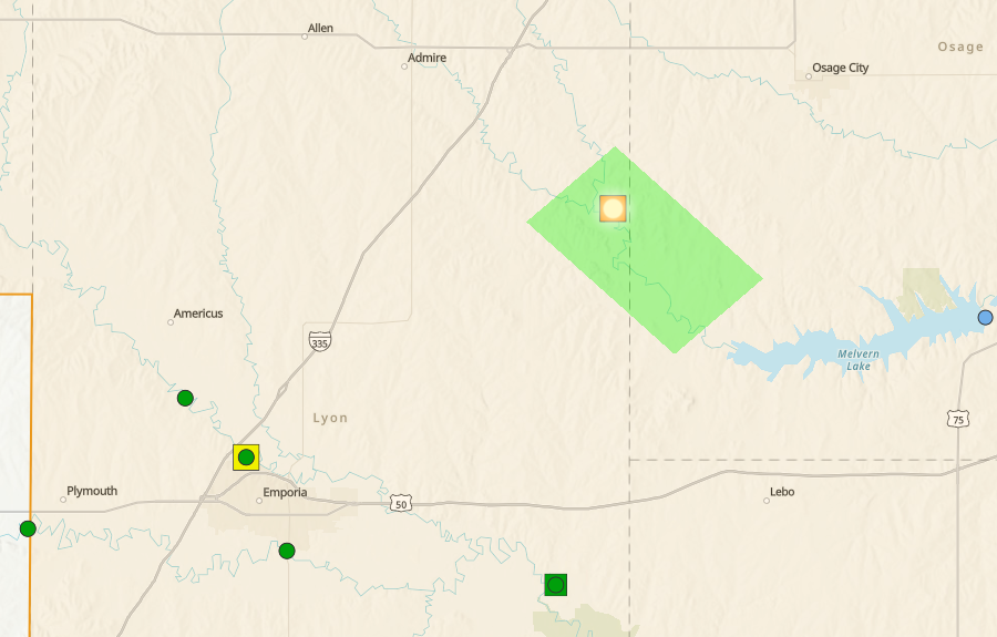
Flooding is underway, but it is highly localized after major rainfall totals Tuesday afternoon into early Wednesday morning.
Flooding developed before noon at the Marais des Cygnes River gauge above Reading. At last check, the river was around 19.6 feet, above flood stage of 19 feet. The river is in a flood warning until Thursday morning, but it may well go back within its banks before sunset Wednesday.
As of noon, the only other gauge moving towards the so-called “action stage” — meaning a river is closing in on flood stage — is the Neosho River at Emporia. The river was just under 13 feet as of noon, below flood stage of 19 feet. The current projection has the river cresting at 15.5 feet early Thursday.
Minimal flooding has been in the picture all day despite rain totals ranging from 2-4.5 inches along and north of Interstate 35 and US Highway 50:
*KVOE studios: 3 inches
*Emporia Municipal Airport: 1.32 inches
*3 miles east of Emporia Municipal Airport: 1.33 inches
*3.5 miles west of Emporia Golf Course: 1.70 inches
*7th and Market: 2.70 inches
*9th and Burns: 4 inches
*18th and Briarcliff: 3.10 inches
*South and Sylvan: 2 inches
*700 block Sunrise: 2.60 inches
*1100 block Constitution: 2.75 inches
*Coronado Avenue: 2.90 inches
*Deerbrook Addition: 3.30 inches
*Frontier Way: 3 inches
*Mount Vernon Terrace: 3.30 inches
*Sonora Drive: 2.80 inches
*6 miles northeast of Emporia: 3 inches
*3 miles northwest of Emporia: 2.88 inches
*7 miles southwest of Emporia: 2.80 inches
*Americus: 4.50 inches
*Allen: 3.90 inches
*1 mile north of Allen: 4.15 inches
*Bushong: 2.94 inches
*Camp Wood: 2.50 inches
*Cottonwood Falls: 2.50 inches
*Council Grove Marina: 2.0 inches
*Emporia Energy Center: 3 inches
*Hartford: 1 inch
*11 miles south of Hartford: 0.20 inches
*Kansas Highway 99 at Lyon-Greenwood county line: 0.50 inches
*Lebo Heidi Inn: 0.75 inches
*2 miles north of Lebo: 1.25 inches
*2100 block Lyon County Road J-7: 3.50 inches
*Neosho Rapids: 0.80 inches
*Olpe Blacksmith Shop: 2 inches
*2 miles north of Olpe: 1 inch
*5 miles southwest of Olpe: 0.90 inches
*Reading: 3 inches
*2.5 miles northeast of Reading: 2.12 inches
*1 mile north of Saffordville: 3.20 inches
*Thorndale: 2.50 inches
*Toledo: 1.50 inches
Unsettled weather conditions take a break through Friday, with highs in the mid-90s and heat index readings near 100. Showers and storms return to the area Saturday through at least Tuesday. Over half an inch of rain is possible this upcoming weekend.
KVOE and KVOE.com will have updates.
8 am Wednesday
We are going from overly dry to overloaded in a hurry.
After over a month with little to no rainfall, Mother Nature is making up for lost time. Waves of moderate to heavy rainfall doused the KVOE listening area Tuesday afternoon into early Wednesday morning, leaving some impressive totals behind.
National Weather Service meteorologist Chelsea Picha says a stalled-out cold front generated the heavy rainfall.
This follows anywhere from 1.5-6 inches of rainfall across the area from activity last Wednesday into Thursday and this past weekend.
Low-water crossings north of Emporia have some water over them, but Lyon County Sgt Chuck Moore says most of the rainfall has already run off. The Lyon County Highway Department has not listed any roads so far that it will need to repair due to flooding. Flood gauges at different points along the Cottonwood and Neosho rivers have increased, but most are nowhere close to flood stage.
Currently, the only gauge indicated as approaching flood stage is the Marais des Cygnes near Reading, which is in a flood warning until Thursday morning. Flood stage is 19 feet. The river should crest at 20.5 feet Wednesday afternoon and quickly go back below flood stage.
A flood watch continues for Lyon, Coffey, Morris, Osage and Wabaunsee counties until 1 pm Wednesday.
Rainy conditions Tuesday afternoon led to an injury crash on the Kansas Turnpike near Emporia. The Kansas Highway Patrol says 2 vehicles were southbound in the outside lane when a car driven by 77-year-old Barbara Choiniere of Tonopah, Arizona, rear-ended a car driven by 66-year-old Scott Krause of Shawnee. Choiniere was taken to Newman Regional Health with suspected minor injuries. Troopers say Choiniere was following the Krause car too closely before the wreck happened.
High temperatures will be in the 90s as dry conditions return through Friday. Several boundaries are currently expected to cross the area from Saturday through the middle of next week, giving us more chances of rainfall. The best chances are currently Saturday night.
If you have rain totals or storm reports, message the KVOE Bluestem Farm and Ranch Supply text line at 620-342-5863. If you have storm video, direct message Facebook@kvoenews.
8:30 am Tuesday: Heavy rain, severe storms possible Tuesday
Thunderstorms could bring heavy rain and severe-level wind to the area later Tuesday.
Showers and storms are expected areawide by late afternoon, if not sooner, and could extend into much of Wednesday morning. On the severe weather side, there is a marginal risk for wind gusts up to 60 mph and hail up to 1 inch in diameter for the afternoon and evening hours. Rainfall totals could approach an inch in and around Emporia by sunrise Wednesday.
High temperatures will be in the low 90s Tuesday and Wednesday, and highs will be in the 90s through Saturday with chances of rain returning Friday night and continuing through the upcoming weekend. The current forecast indicates high temperatures in the upper 80s Saturday and mid-70s Sunday.
Stay with KVOE and KVOE.com for updates.
















