


Possibilities of slick travel conditions Thursday night and Friday morning have prompted the National Weather Service to expand winter weather advisories.
Originally, Osage and Wabaunsee counties were in an advisory until 3 am Friday. That advisory has been extended to expire at 6 am and expanded to include Lyon and Coffey counties. Chase and Greenwood counties are in a separate advisory until 3 am and Morris County is in an advisory until midnight.
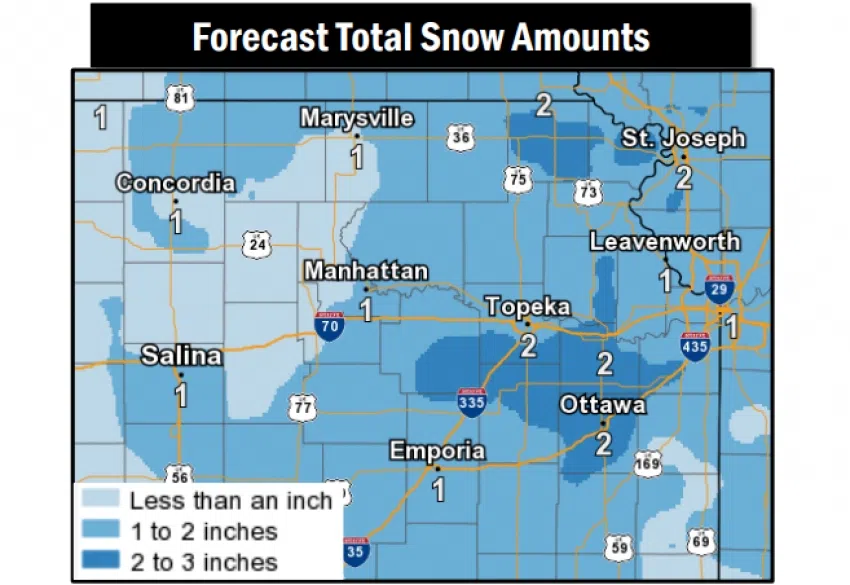
A rain-snow mix will change to all snow after sunset, leading to isolated or scattered slick spots before everything ends after midnight. Up to two inches total accumulation are expected, with higher amounts north of Emporia and Burlington.
Stay with KVOE, KVOE.com and KVOE social media for updates. Join KVOE on Facebook@kvoenews and Twitter@kvoeam1400 for weather and travel updates if you are not already connected. If you have schedule adjustments, call KVOE at 620-342-1400 or email kvoe@kvoe.com.
11:30 am Thursday: Chase and Greenwood counties added to list of winter weather advisories
Chase and Greenwood counties have traded in dense fog for a potential round of wintry precipitation through Friday morning.
The National Weather Service has placed Chase and Greenwood into a winter weather advisory from 4 pm Thursday through 3 am Friday. This follows a separate advisory issued for Osage and Wabaunsee counties from noon Thursday to 3 am Friday.
Light rain and snow are expected for much of the day before a change to all snow by late afternoon or early evening as temperatures dip below freezing. Not much snow is expected — half an inch or less before midnight, maybe another inch overnight — but there could be slick travels in spots. As a result, Osage and Wabaunsee counties are in a winter weather advisory from noon Thursday to 3 am Friday.
Stay with KVOE, KVOE.com and KVOE social media for updates.
7 am Thursday: Winter weather advisories slated for Osage, Wabaunsee counties
Now that dense fog advisories have lifted for Chase and Greenwood counties, we should get through most of Thursday without any widespread weather-related travel issues. However, light snow could cause isolated problems for the evening and overnight hours, especially to our northeast.
Light rain and snow are expected for much of the day before a change to all snow by late afternoon or early evening as temperatures dip below freezing. Not much snow is expected — half an inch or less before midnight, maybe another inch overnight — but there could be slick travels in spots. As a result, Osage and Wabaunsee counties are in a winter weather advisory from noon Thursday to 3 am Friday.
Stay with KVOE, KVOE.com and KVOE social media for updates.
5:30 am Thursday: Dense fog, winter weather advisories announced near Emporia
Travel conditions are being affected in two different ways the next 24 hours.
The concern Thursday morning is fog, especially south and west of Emporia. The National Weather Service has extended a dense fog advisory for Chase County so it ends at 7 am instead of 6 am, and it has expanded it to include Greenwood County. Visibility could be a quarter-mile or less in spots until the advisory ends.
Once that clears, we can expect light rain and snow for much of the day before it changes to all snow by late afternoon or early evening as temperatures dip below freezing. Not much snow is expected — half an inch or less before midnight, maybe another inch overnight — but there could be slick travels, especially to our northeast. As a result, Osage and Wabaunsee counties are in a winter weather advisory from noon Thursday to 3 am Friday.
Stay with KVOE, KVOE.com and KVOE social media for updates. Join KVOE on Facebook@kvoenews and Twitter@kvoeam1400 for weather and travel updates if you are not already connected. If you have schedule adjustments, call KVOE at 620-342-1400 or email kvoe@kvoe.com.
 (1)")


")