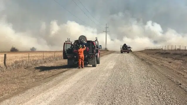
Burning will be prohibited across the KVOE listening area Friday with red flag warnings now in effect across all area counties.
The National Weather Service has issued a Red Flag Warning for Lyon, Coffey, Morris, Osage and Wabaunsee counties from noon to 9 pm Friday. Chase and Greenwood counties are in a separate Red Flag Warning from 11 am to 9 pm Friday.
Red Flag Warnings mean automatic burn bans for all affected counties. Chase, Osage and Greenwood counties have also issued burn bans for Thursday.
Wind advisories are also in place for Lyon and most surrounding counties through 7 pm Friday with the only exception being Greenwood county which is in an advisory until 1 pm Friday and a high wind warning from 1 pm to 7 pm Friday.
10 am Thursday: WEATHER: Severe weather risk removed, but high winds and related fire, outage dangers remain
Chances of strong storms have been removed for the KVOE listening area early Friday.
The marginal risk for borderline severe hail and wind in place across the eastern half of the state have been pushed into Oklahoma as part of the Storm Prediction Center’s 8 am outlook.
However, there are numerous official alerts connected to the incoming high winds and increasing fire danger. A wind advisory includes Lyon, Coffey, Morris, Osage and Wabaunsee counties from noon Thursday until 7 pm Friday, while Chase County is in a wind advisory from 11 am Thursday to 7 pm Friday and Greenwood County is in a separate advisory from 11 am Thursday to 11 am Friday.
Burn bans have been announced for Chase, Osage and Wabaunsee counties for Thursday — which lead to weather alerts already in place for Friday. There is a red flag warning, meaning automatic burn bans, for Chase and Greenwood counties from 11 am to 9 pm Friday — along with a high wind watch for Greenwood County from 11 am to 7 pm Friday. Lyon County and other surrounding counties are in a fire weather watch, often a precursor to red flag warnings, from 12-9 pm Friday.
Besides rekindles, a concern after several grass fires developed in Lyon County on Wednesday, the high winds could also cause widespread power outages and travel issues for high-profile vehicles.
5:30 am Thursday: High winds, bad fire conditions, low-end severe weather risk all in short-term forecast
Severe weather is possible, but high winds are likely across the KVOE listening area in the short-term weather forecast.
The severe weather picture involves a marginal risk for all area counties by the overnight hours early Friday. Wind and hail are the main concerns now if storms develop. The non-zero tornado risk in Wednesday’s forecasts has pushed south into Oklahoma.
Meanwhile, there are numerous official alerts connected to the incoming high winds and increasing fire danger. A wind advisory includes Lyon, Coffey, Morris, Osage and Wabaunsee counties from noon Thursday until 7 pm Friday, while Chase County is in a wind advisory from 11 am Thursday to 7 pm Friday and Greenwood County is in a separate advisory from 11 am Thursday to 11 am Friday. There is a red flag warning, meaning automatic burn bans, for Chase and Greenwood counties from 11 am to 9 pm Friday — along with a high wind watch for Greenwood County from 11 am to 7 pm Friday. Lyon County and other surrounding counties are in a fire weather watch, often a precursor to red flag warnings, from 12-9 pm Friday.
TV-13 meteorologist Doug Meyers is urging landowners to make sure any fires from earlier this week are totally out as conditions worsen.
Rekindles are a concern, especially after several small grass fires developed in Lyon County on Wednesday afternoon and evening.
Fire developed near Roads 350 and W-7 shortly before 2 pm. Miller and Reading crews handled that incident.
Emporia and Olpe handled a small fire that developed in the 1200 block of Road 137 shortly before 4 pm. The fire burned less than an acre, but it happened in a wooded area.
Emporia also responded to the 2800 block of Road P shortly after 7 pm. Details about that incident are currently pending.
Other wind-related concerns include the risk of widespread power outages and travel problems, especially for high-profile vehicles.
We’ll keep you updated on the severe weather risk, wind and fire danger as things unfold on KVOE, KVOE.com and KVOE social media.


