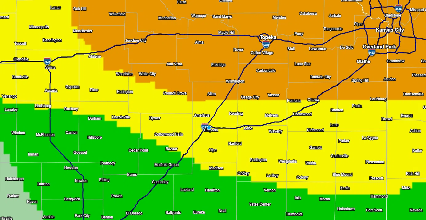
All severe weather hazards remain in play for the KVOE listening area the rest of Wednesday evening.
A warm front lifting into northeast Kansas has prompted a marginal-to-enhanced risk south-to-north for the listening area. Areas along and north of US Highway 56 are in the enhanced risk area. Areas south of an Elmdale-to-Madison line are in a marginal risk, with the rest of the listening area, including Emporia, in a slight risk.
As has been the case all day, very large hail — at least egg-sized — is the main concern with any storms that develop. Storms could also produce tornadoes and straight-line wind speeds up to 70 mph.
Stay with KVOE, KVOE.com and KVOE social media for updates. Be sure to track alerts on KVOE social media — Facebook@kvoenews, Instagram@kvoenews and X@kvoeam1400.
Noon Wednesday:
The KVOE listening area is in a marginal-to-enhanced severe weather risk from late afternoon to late evening, with areas along and north of US Highway 56 in the enhanced risk — increasing the risk for the northern third of the listening area in the process.
The Storm Prediction Center’s 8 am outlook still calls for hail 2 inches in diameter or larger as the lead threat, along with wind gusts up to 70 mph and isolated tornadoes. As TV-13 meteorologist Doug Meyers mentioned early Wednesday, storms are expected to fire along a frontal boundary moving across the east half of Kansas by late afternoon. The most concentrated risk appears to be in northeast Kansas and northwest Missouri.
Stay with KVOE, KVOE.com and KVOE social media for updates through the day.
6:15 am Wednesday: Conditional severe storm risk in place by late Wednesday afternoon
Area residents have a low-end severe weather risk by late Wednesday afternoon.
The KVOE listening area is in a marginal-to-slight risk from late afternoon to late evening. TV-13 meteorologist Doug Meyers says storms will fire along a warm front. The question is where the front will be when the storms pop.
Hail 2 inches in diameter, or egg size, and larger is the main threat. Storm winds up to 70 mph are possible and an isolated tornado can’t be ruled out.
Temperatures will climb into the upper 70s before the severe weather risk develops. Chances of showers and non-severe storms diminish through the day Thursday.
KVOE and KVOE.com will have updates through the day.


