


Heavy snowfall and dangerously cold temperatures are expected to impact the KVOE listening area through much of the upcoming work week.
In fact, the National Weather Service is expanding a previously issued winter storm watch to now include the entire KVOE listening area from late Monday night through late Tuesday with an extreme cold watch effecting Lyon, Chase, Coffey, Morris, Osage and Wabaunsee counties Monday through Thursday and Greenwood County Tuesday through Thursday. The storm watch reflects heavy snowfall expected to impact the area Monday through Tuesday.
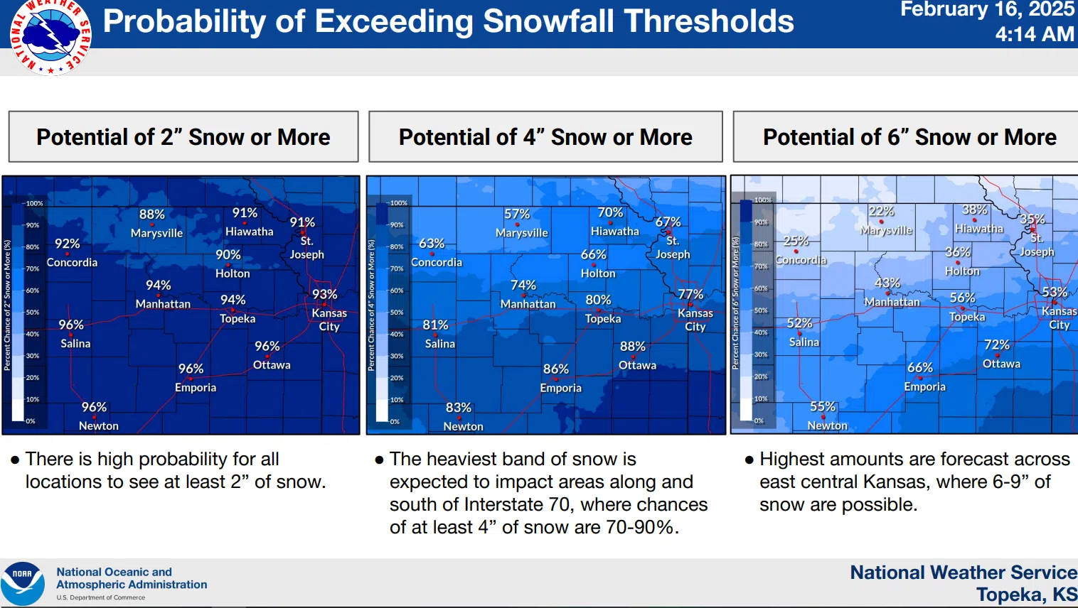
The National Weather Service has upped its previous projections of 4 to 8 inches to 5 to 9 inches for areas along the Interstate 35 corridor. On top of the large snow totals, NWS is anticipating wind gusts as high as 30 mph at times throughout this period which will drive windchills into negative territory for much of the week.
High temperatures are expected to be in the mid to low teens through much of the week with overnight lows in the single digits and windchills between -2 and -8 Monday through Thursday. With this information in mind, travel, especially Tuesday, is being discouraged, however, if you do have to be out you are reminded to take proper precautions including having an emergency kit in your vehicle.
Be sure to stay with KVOE, KVOE.com and KVOE social media for weather, travel and schedule adjustment updates. If you have schedule adjustments to announce, call KVOE at 620-342-1400, message the Bluestem Farm and Ranch text line at 620-342-5863 or email kvoe@kvoe.com.
11:50 pm Saturday: Lyon, most surrounding counties in winter storm watch Tuesday into early Wednesday
Forecasts are trending towards moderate to heavy snow for much of the KVOE listening area Tuesday — and brutal cold areawide for much of next week.
Lyon, Chase, Coffey, Greenwood, Morris and Osage counties are now in a winter storm watch from 12 am Tuesday to 6 am Wednesday. Wabaunsee County is not currently in a weather advisory, but the National Weather Service says the current alert might be expanded further north.
Current projections indicate 4 to at least 8 inches of snow with pockets of heavier amounts Tuesday into early Wednesday. High temperatures will struggle to the upper single digits and winds could gust as high as 30 mph Tuesday, causing near-blizzard conditions while keeping wind chills near -10. The Weather Service says people with travel plans Tuesday should consider changing them and, at the very least, have an emergency travel kit in their vehicles.
The bitter cold actually begins impacting the area Monday night, with an air temperature of 3 and wind chills under -10. Tuesday night will have an air temperature of -6 with wind chills under -20, while Wednesday night will have an air temperature of -10 and Thursday night will have an air temperature of -5 before conditions finally moderate.
Be sure to stay with KVOE, KVOE.com and KVOE social media for weather, travel and schedule adjustment updates. If you have schedule adjustments to announce, call KVOE at 620-342-1400, message the Bluestem Farm and Ranch text line at 620-342-5863 or email kvoe@kvoe.com.
6:15 am Saturday: Area’s latest snowfall event tentatively coming Monday night
A raw Saturday afternoon sets up a wintry week across the KVOE listening area.
Temperatures in the upper 30s and relatively calm conditions Saturday morning will give way to blustery and damp conditions before noon, with a slight chance of drizzle or freezing rain changing to snowfall through the afternoon hours.
High temperatures will be noticeably cooler Sunday in the low 20s before climbing to around 30 Monday.
Snowfall develops early Tuesday and stays with us through the evening hours, with anywhere from 2-6 inches or more of snowfall driven by northeasterly winds as high as 30 mph. Projected snowfall amounts may still change between now and Tuesday morning.
Biting cold follows the snow, with high temperatures in the low teens Thursday and low 20s Friday. Overnight lows could be -5 to -10 with wind chills under -20 Tuesday night.
Stay with KVOE, KVOE.com and KVOE social media for updates. We already have a handful of schedule adjustments for Tuesday. If you need to add to our list, message the Bluestem Farm and Ranch text line at 620-342-5863 or email kvoe@kvoe.com.


