


Rainy conditions have now transitioned to snowfall across the KVOE listening area.
Snowfall began just before 5 pm following light rainfall through much of the day which transitioned to a rain-snow mix by the late afternoon hours. High wind warnings are still in effect for the entire area through 7 pm Wednesday and combined with the current snowfall could cause some complications for travelers, specifically reduced visibility.
With that in mind, motorists are reminded to take necessary precautions including reducing speed, increasing distance between themselves and other vehicles and eliminating all distractions while behind the wheel. Snow fall is expected to continue into the late evening hours, however, little to no accumulation is expected thanks to warm ground temperatures as a result of warmer air temperatures in the mid to upper 70s for the past several days.
Overnight lows are expected to be in the upper 20s and while it is much colder than what we have become accustomed to in recent weeks, it will also likely mean little to no ice accumulation in the overnight hours which is very good news, especially for the morning commute. Once the snowfall subsides, more seasonal temperatures are expected heading into the upcoming weekend with temperatures in the mid to high 60s and plenty of sunshine through Sunday.
Stay with KVOE, KVOE.com and KVOE social media for more weather updates as needed.
6:20 am Wednesday: High wind warnings Wednesday, rain-snow mix also expected
A windy, wintry day is ahead for the KVOE listening area Wednesday.
After temperatures peaking in the upper 70s Tuesday and temperatures in the upper 60s as late as 4 am Wednesday, the bottom drops out of the temperatures and wind gusts continue between 50-60 mph. And we have a rain-snow combination to deal with as well, especially for the afternoon hours.
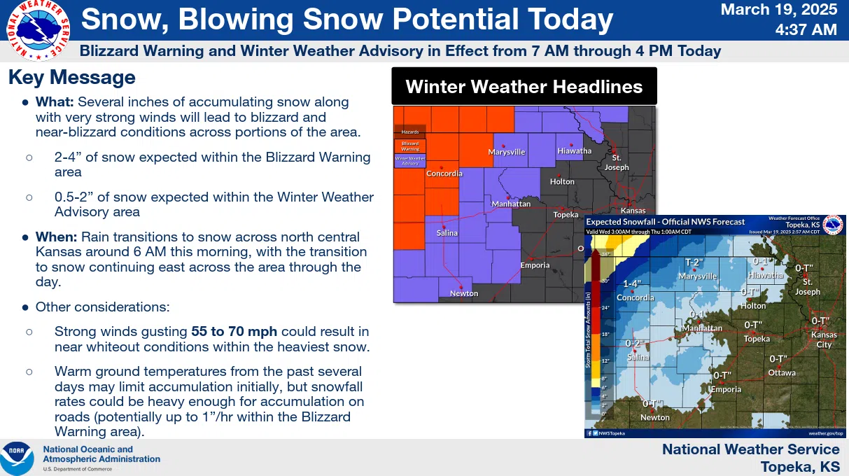
High wind warnings are now active areawide until 7 pm, and Chase and Morris counties are in a winter weather advisory from 7 am to 4 pm
Because surface temperatures will be well above freezing, TV-13 meteorologist Doug Meyers expects little to no snow accumulation, even though it may be coming down at a heavy rate at times. However, there could be some travel concerns.
Both Emporia Public Works Director Dean Grant and Lyon County Engineer Chip Woods say they do not expect any major travel impacts Wednesday, but both entities will be ready just in case.
Power outages and downed limbs or, in some cases trees, are expected. High-profile vehicles like large trucks will also struggle in the wind, especially those traveling east or west.
Be sure to stay with KVOE, KVOE.com and KVOE social media for updates.


