


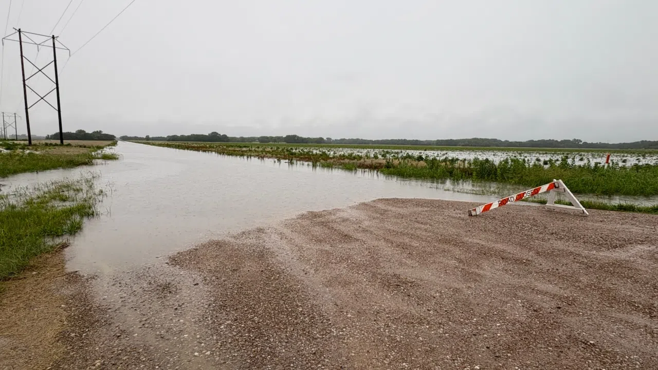
Kansas Highway 99 is closed north of Emporia and may well close south of town later this week due to extremely heavy rainfall and related flooding.
The Kansas Department of Transportation has closed K-99 between Interstate 35 and Road 240, a stretch of nearly six miles, as floodwaters continue to rise and shift following 4-plus inches of rainfall Tuesday. Projections for the Cottonwood River show the river cresting at 26 feet early Thursday, above the mark where water goes over both K-99 lanes near Soden’s Grove.
K-99 isn’t the only area highway affected by the heavy rainfall. Kansas Highway 58 is closed between K-249 and the Greenwood-Coffey county line due to flooding, while K-249 near Madison is closed due to a failed box bridge.
Lyon County road closures
*Road 50 from Highway 99 to Road R
*Road 130 between Road R and S
*Road 140 between Road J and Kansas Highway 99
*Road 150 between Road K and Kansas Highway 99
*Road 150 from Road D to Road F
*Road 150 from Road M to Road N
*Road 150 between Road W and Road X
*Road 160 from Road N to Road R
*Road 170 from Road M7 to Road R1
*Road 170 from Road Y to Road Z
*Road 165 from Road M to Road N
*Road 190 from Burlingame Road to Road L5
*Road 200 from Road R to Road S
*Road 225 from Road F to Road F5
*Road 240 from D to the Americus City Limits
*Road 240 from Road E to Road C
*Road 250 from Road D to Road E
*Road 260 from Road D to Road E
*Road 270 from Road E to Road F
*Road 27 from Road D to Road F
*Road A from Highway 50 to Road 180
*Road D from Road 260 to 270
*Road E from 260 to 270
*Road F from 225 to 235
*Road G from Road 50 to Road 60
*Road J between Roads 140 and 160
*Road K between Roads 130 and 150
*Road K5 from Road 70 to Road 80
*Road M between Roads 110 and 120
*Road M from Road 190 to Road 197
*Road N from Road 160 to Road 170
*Road P from Road 40 to Road 60
*Road P from Road 150 to Road 170
*Road R from Road 150 to Road 170
In Emporia:
*South Walnut and Copley
*East 12th and Whilden
*Randolph Avenue closed from Southwest to Walnut
*18th Avenue from Highland to Burlingame
Weaver Street between US Highway 50 and the Hill’s Pet Nutrition plant has been reported as flooded in spots.
Area road closures:
Chase County
*Portions of Roads XX, YY, Z, ZZ near Lake Kahola
*V between Cedar Point and US50/railroad tracks in both direction
*Camp Wood Road from Elmdale to south end
*PR between Lake Road and 215
*N between US50 north to end
*K177 spots where water is going over. NOT closed
*227 between Cottonwood Falls and K177
*120 east of B, between B and C
*Cedar Creek Road closed and impassable
*88 from Cedar Creek to Marion County line
*B south of US 50
*Norton Creek east of the tracks
*Sharps Creek south of Bazaar
Coffey County
*Numerous roads listed as closed. Full list pending
Greenwood County
*Kansas Highway 58 east of Madison
*State Street bridge and Seventh Street bridge in Eureka
*375th and X, between BB and CC
Morris County
*S 400 and S 500 near Lake Kahola
*100 block of South Rockhill in Council Grove barricaded
Osage County
*325th and Shawnee Heights
*Fairlawn north of Scranton
*Oak between High and Roberts in Melvern
*Burlingame Road north of Burlingame
Flooded roads led to at least one water rescue south of Emporia as Emporia Fire/EMS and Lyon County deputies responded to Roads 145 and H shortly before 3:30 pm. One person was extricated and taken to safety.
Current rain totals
*KVOE studios: 4.4 inches
*Emporia Municipal Airport: 1.88 inches
*300 block South Cottonwood: 4.2 inches
*Hammond Heights: 2.20 inches
*South and Sylvan: 1.60 inches
*Willow Lane: 1.60 inches
*Ninth and Lawrence: 4.3 inches
*6 miles northeast of Emporia: 2.30 inches
*3.5 miles west of Emporia Golf Course: 6.50 inches
*Allen: 3.60 inches
*Americus: 1.10 inches
*5 miles NE of Americus: 2.93 inches
*First and Locust in Americus: 1.72 inches
*Council Grove Reservoir: 0.13 inches
*Eureka Milliken Airport: 0.55 inches
*Between Hatford and Olpe: 3.50 inches
*Hartford: 2.75 inches
*2 miles north of Lebo: 1 inch
*Neosho Rapids: 3 inches
*400 block Iowa in Olpe: 5.50 inches, pond is full
*2 miles southwest of Olpe: 4.70 inches
*Thorndale: 5 inches
*1.5 miles east of Thorndale: 5.5 inches
*1 mile north of Saffordville: 6 inches
*Ninth and Lawrence: 4.4 inches
*1800 block of Coronado Avenue: 4 inches
*1.5 miles north of Plymouth: 3.45 inches
*900 block Burns: 4 inches
*10th and Weaver: 3.7 inches
*Road 180 between Road E and E5: 3 inches
*290 and YY Rd: 3.5 inches
*Country Club Heights: 3.7 inches
*West 22nd Avenue: 4 inches
*8 miles north of Burlington: 2.59 inches
4-11 am Tuesday: Heavy rain already reported, roads re-closing in Lyon County
Heavy rain is likely and severe weather is still possible across the KVOE listening area before midnight.
Rainfall totals could be anywhere from 1.5-3 inches areawide by Tuesday night, possibly triggering another round of flooding after over five inches of rain led to river-based flooding for the Cottonwood at Emporia and Neosho at Neosho Rapids for much of last week. TV-13 meteorologist Doug Meyers expects a lot of rainfall areawide later Tuesday.
Here locally, the Mechanic Street underpass was blocked briefly due to heavy rain before sunrise, and several Lyon County roads are closed — again — after periods of closures last week:
*Road 50 from Highway 99 to Road R
*Road 140 between Road J and Kansas Highway 99
*Road 150 between Road K and Kansas Highway 99
*Road 150 from Road D to Road F
*Road 150 from Road M to Road N
*Road 160 from Road N to Road R
*Road 170 from Road M7 to Road R1
*Road 170 from Road Y to Road Z
*Road 165 from Road M to Road N
*Road 190 from Burlingame Road to Road L5
*Road 200 from Road R to Road S
*Road 240 from Road E to Road C
*Road 250 from Road D to Road E
*Road 270 from Road D to Road F
*Road A from Highway 50 to Road 180
*Road G from Road 50 to Road 60
*Road J between Roads 140 and 160
*Road K between Roads 130 and 150
*Road K5 from Road 70 to Road 80
*Road M from Road 190 to Road 197
*Road N from Road 160 to Road 170
*Road P from Road 40 to Road 60
*Road P from Road 150 to Road 170
*Road R from Road 150 to Road 170
In Emporia:
*South Walnut and Copley
*East 12th and Whilden
*Randolph Avenue closed from Southwest to Walnut
*18th Avenue from Highland to Burlingame
Weaver Street between US Highway 50 and the Hill’s Pet Nutrition plant has been reported as flooded in spots.
Area road closures:
Chase County
*Portions of Roads XX, YY, Z, ZZ near Lake Kahola
Morris County
*S 400 and S 500 near Lake Kahola
*100 block of South Rockhill in Council Grove barricaded
Current rain totals:
*KVOE studios: 4.2 inches
*Emporia Municipal Airport: 1.88 inches
*300 block South Cottonwood: 4.2 inches
*Hammond Heights: 2.20 inches
*South and Sylvan: 1.60 inches
*Willow Lane: 1.60 inches
*6 miles northeast of Emporia: 2.30 inches
*3.5 miles west of Emporia Golf Course: 6.50 inches
*Allen: 0.70 inches
*Americus: 1.10 inches
*First and Locust in Americus: 1.72 inches
*Council Grove Reservoir: 0.13 inches
*Eureka Milliken Airport: 0.55 inches
*Between Hatford and Olpe: 3.50 inches
*Hartford: 2.75 inches
*2 miles north of Lebo: 1 inch
*Neosho Rapids: 3 inches
*400 block Iowa in Olpe: 5.50 inches, pond is full
*2 miles southwest of Olpe: 4.70 inches
*Thorndale: 2.50 inches
*1.5 miles east of Thorndale: 5.5 inches
*Ninth and Lawrence: 4.2 inches
*1800 block of Coronado Avenue: 4 inches
*1.5 miles north of Plymouth: 3.45 inches
*900 block Burns: 4 inches
*10th and Weaver: 3.7 inches
*Road 180 between Road E and E5: 3 inches
*290 and YY Rd: 3.5 inches
*Country Club Heights: 3.7 inches
*West 22nd Avenue: 4 inches
*8 miles north of Burlington: 2.59 inches
Emporia Fire has been dispatched to two reported injury crashes on the Kansas Turnpike, one at mile marker 106 — between the Flint Hills cattle pens exit and the Matfield Green service area — and one at mile marker 112, or just outside the cattle pens exit. Additional details are pending.
There is also a severe weather possibility, although Meyers says severe weather may depend a lot on morning cloud cover and rain activity. As it stands, the Storm Prediction Center has area counties in a marginal to slight risk, with areas east of the Kansas Turnpike in the slight risk area. Hail up to the size of quarters and gusts up to 60 mph are the main hazards, with a brief spin-up tornado possible.
Lightning from morning storms shut of power to around 100 Evergy customers areawide, including 70 between Emporia and Olpe.
KVOE and KVOE.com will have updates. If you have rain totals, message the KVOE Bluestem Farm and Ranch Supply text line at 620-342-5863.


