


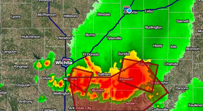
Part of the KVOE listening area is dealing with a severe weather risk Sunday evening.
Storms moving through southern Greenwood County generated 60 mph winds in Severy during a severe thunderstorm warning. Additional severe weather reports are pending.
Storms earlier Sunday caused two injury wrecks that happened almost simultaneously in the same area of the Kansas Turnpike.
Both crashes happened just before 6 pm at mile marker 98.6, or less than two miles northeast of the Matfield Green service exit. In the first wreck, an SUV driven by 41-year-old Carl Bennett of Americus was passing a semi when it hydroplaned and hit the center barrier wall. Bennett was not hurt, but a passenger, 41-year-old Ashley Bennett of Americus, was taken to Newman Regional Health with suspected minor injuries.
The second crash happened as a car driven by 25-year-old Isabella Jackson of Kearney, Missouri, was slowing down as the first crash was developing in front of her. An SUV driven by 22-year-old Kyle Bryan of Mason, Ohio, rear-ended Jackson’s car, sending Bryan to Newman Regional Health with suspected minor injuries. Jackson was not hurt.
All area counties are in a marginal severe weather risk for late Sunday through early Monday morning. There have been several severe thunderstorm warnings for portions of Greenwood County south of US Highway 54, and that same area is in a flood warning until 12:30 am Monday.
KVOE and KVOE.com will have updates.
10:30 am Sunday: Severe weather, heavy rainfall possible Sunday night
Showers and thunderstorms will become increasingly likely as we go from Sunday afternoon through early Monday morning, and some of the evening and late-night storms could be severe.
The Storm Prediction Center has outlined a slight severe weather risk for all area counties through early Monday, with the main time of concern starting by mid-evening. Winds up to 60 mph and hail to the size of quarters are the main severe weather risks by mid-evening.
Heavy rain is also possible with abundant moisture and slow storm movement expected.
The general forecast resembles Thursday, which had a low-end wind and heavy rain risk that did not materialize in or around Emporia.
KVOE and KVOE.com will have updates. If you have rain totals or severe weather reports, message the KVOE Bluestem Farm and Ranch Supply text line at 620-342-5863.
 (1)")


")